Foot of Ten, Pennsylvania
Census-designated place in Pennsylvania, United States
40°24′57″N 78°27′19″W / 40.41583°N 78.45528°W / 40.41583; -78.45528 (2020)[2]
16635[3]
Foot of Ten is a census-designated place[5] in Allegheny and Juniata Townships in Blair County, Pennsylvania, United States. It is located approximately one mile west of the small borough Duncansville on Foot of Ten Road, and about 2.5 miles (4 km) north of the even smaller borough Newry. It is often considered a region of Duncansville, despite lying outside the borough limits. As of the 2010 census, the population was 672 residents.[6]
The town was named Foot of Ten because of its location at the foot of the tenth inclined plane of the Allegheny Portage Railroad.[7][8]
-
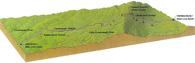 Profile of the original line of the portage railroad from Hollidaysburg, PA to Johnstown, PA. Foot of Ten lies just east of the inclined plane labeled 10.

Demographics
| Census | Pop. | Note | %± |
|---|---|---|---|
| 2020 | 560 | — | |
| U.S. Decennial Census[9] | |||
As of 2020, 560 people live in Foot of Ten.
See also
- Puzzletown, a nearby unincorporated place on Puzzletown Road.
References
- ^ "ArcGIS REST Services Directory". United States Census Bureau. Retrieved October 12, 2022.
- ^ "Census Population API". United States Census Bureau. Retrieved October 12, 2022.
- ^ "Foot of Ten PA ZIP Code". zipdatamaps.com. 2023. Retrieved October 31, 2023.
- ^ U.S. Geological Survey Geographic Names Information System: Foot of Ten, Pennsylvania
- ^ "2010 Census". Archived from the original on December 23, 2013. Retrieved February 10, 2013.
- ^ Bureau, US Census. "Census.gov". www.census.gov. Retrieved July 23, 2016.
- ^ "Allegheny Portage Railroad". History & Culture. National Park Service. Retrieved November 15, 2016.
- ^ "Funny Name". Foot of Ten Independent Baptist Church. Retrieved November 15, 2016.
- ^ "Census of Population and Housing". Census.gov. Retrieved June 4, 2016.
- v
- t
- e
Municipalities and communities of Blair County, Pennsylvania, United States
County seat: Hollidaysburg

- Bald Eagle
- Beavertown
- Blue Knob
- Brooks Mill
- Canan Station
- Canoe Creek
- Carson Valley
- Charlottsville
- Clappertown
- Claysburg
- Cotton Town
- Cove Forge
- Cross Keys
- Culp
- Curryville
- Dumb Hundred
- East Altoona
- East Freedom
- East Sharpsburg
- Elberta
- Eldorado
- Fisherville
- Foot of Ten
- Fort Fetter
- Fostoria
- Franklin Forge
- Frankstown
- Fredericksburg
- Friesville
- Ganister
- Geeseytown
- Gray
- Grazierville
- Greenwood
- Henrietta
- Homewood at Martinsburg
- Ironville
- Jugtown
- Juniata Gap
- Klahr
- Lakemont
- Larke
- Leamersville
- Linds Crossing
- Loop
- Martinsburg Junction
- McKee
- Mill Run
- Millerstown
- Moores Mill
- Nealmont
- Newburg
- Northwood
- Olivia
- Ore Hill
- Oreminea
- Penn Farms
- Pinecroft
- Point View
- Puzzletown
- Red Hill
- Reese
- Reightown
- Reservoir
- Robeson Extension
- Roots
- Royer
- Shelltown
- Shellytown
- Sickles Corner
- Skelp
- Ski Gap
- Smith Corner
- Spring Drive Mobile Home Park
- Sproul
- St. Clair
- Sunbrook
- Sylvan Hills
- Tipton
- Tyrone Forge
- Vail
- Vicksburg
- Wopsononock
- Yellow Springs
‡This populated place also has portions in an adjacent county or counties
- Pennsylvania portal
- United States portal


