Fichtwald
Municipality in Brandenburg, Germany
Location of Fichtwald within Elbe-Elster district

(2019–24) Peggy Bulst[1]
(2022-12-31)[2]
04936
Fichtwald is a municipality in the Elbe-Elster district, in Brandenburg, Germany.
History
From 1815 to 1944, the constituent localities of Fichtwald was part of the Prussian Province of Saxony. From 1944 to 1945, they were part of the Province of Halle-Merseburg. From 1952 to 1990, they were part of the Bezirk Cottbus of East Germany. On 31 December 2001, the municipality of Fichtwald was formed by merging the municipalities of Hillmersdorf, Naundorf and Stechau.
Demography
-
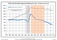 Development of population since 1875 within the current boundaries (Blue line: population; dotted line: Comparison to population development of Brandenburg state; grey background: Time of Nazi rule; red background: Time of communist rule)

|
|
|
References
- ^ Landkreis Elbe-Elster Wahl der Bürgermeisterin / des Bürgermeisters, accessed 1 July 2021.
- ^ "Bevölkerungsentwicklung und Bevölkerungsstandim Land Brandenburg Dezember 2022" (PDF). Amt für Statistik Berlin-Brandenburg (in German). June 2023.
- ^ Detailed data sources are to be found in the Wikimedia Commons.Population Projection Brandenburg at Wikimedia Commons
External links
![]() Media related to Fichtwald at Wikimedia Commons
Media related to Fichtwald at Wikimedia Commons
- v
- t
- e
Towns and municipalities in Elbe-Elster
- Bad Liebenwerda
- Crinitz
- Doberlug-Kirchhain
- Elsterwerda
- Falkenberg/Elster
- Fichtwald
- Finsterwalde
- Gorden-Staupitz
- Gröden
- Großthiemig
- Heideland
- Herzberg (Elster)
- Hirschfeld
- Hohenbucko
- Hohenleipisch
- Kremitzaue
- Lebusa
- Lichterfeld-Schacksdorf
- Massen-Niederlausitz
- Merzdorf
- Mühlberg
- Plessa
- Röderland
- Rückersdorf
- Sallgast
- Schilda
- Schlieben
- Schönborn
- Schönewalde
- Schraden
- Sonnewalde
- Tröbitz
- Uebigau-Wahrenbrück

 | This Brandenburg location article is a stub. You can help Wikipedia by expanding it. |
- v
- t
- e


