Eslamshahr County
County in Tehran province, Iran
County in Tehran, Iran
Eslamshahr County Persian: شهرستان اسلامشهر | |
|---|---|
County | |
 Namaz Square | |
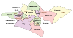 Location of Eslamshahr County in Tehran province (center left, green) | |
 Location of Tehran province in Iran | |
| Coordinates: 35°35′N 51°17′E / 35.583°N 51.283°E / 35.583; 51.283[1] | |
| Country |  Iran Iran |
| Province | Tehran |
| Capital | Eslamshahr |
| Districts | Central, Ahmadabad-e Mostowfi, Chahardangeh |
| Area | |
| • Total | 193 km2 (75 sq mi) |
| Population (2016)[2] | |
| • Total | 548,620 |
| • Density | 2,800/km2 (7,400/sq mi) |
| Time zone | UTC+3:30 (IRST) |
| Eslamshahr County can be found at GEOnet Names Server, at this link, by opening the Advanced Search box, entering "9206100" in the "Unique Feature Id" form, and clicking on "Search Database". | |
Eslamshahr County (Persian: شهرستان اسلامشهر) is in Tehran province, Iran. Its capital is the city of Eslamshahr.[3]
Demographics
Population
At the time of the 2006 National Census, the county's population was 447,192 in 114,009 households.[4] The following census in 2011 counted 485,688 people in 139,408 households.[5] At the 2016 census, the county's population was 548,620 in 168,288 households.[2]
According to the information of the State Meteorological Organization of Iran, the long-term average annual rainfall of Eslamshahr is around 215 mm[6]
Administrative divisions
Eslamshahr County's population history and administrative structure over three consecutive censuses are shown in the following table.
| Administrative Divisions | 2006[4] | 2011[5] | 2016[2] |
|---|---|---|---|
| Central District | 394,151 | 427,883 | 465,353 |
| Ahmadabad-e Mostowfi RD | 14,154 | 15,887 | |
| Bahramabad RD | 9,599 | ||
| Deh Abbas RD | 22,826 | 22,894 | 7,625 |
| Eslamshahr (city) | 357,171 | 389,102 | 448,129 |
| Ahmadabad-e Mostowfi District | 22,611 | ||
| Ahmadabad-e Mostowfi RD | 3,910 | ||
| Chichaklu RD | 4,624 | ||
| Ahmadabad-e Mostowfi (city) | 14,077 | ||
| Chahardangeh District | 53,041 | 57,805 | 60,631 |
| Chahardangeh RD | [a] | 1,607 | |
| Firuzbahram RD | 10,882 | 11,501 | 9,074 |
| Chahardangeh (city) | 42,159 | 46,299 | 49,950 |
| Total | 447,192 | 485,688 | 548,620 |
| RD = Rural District | |||
Villages
See also
![]() Media related to Eslamshahr County at Wikimedia Commons
Media related to Eslamshahr County at Wikimedia Commons
 Iran portal
Notes
- ^ Below the reporting threshold
References
- ^ OpenStreetMap contributors (5 April 2023). "Eslamshahr County" (Map). OpenStreetMap. Retrieved 5 April 2023.
- ^ a b c "Census of the Islamic Republic of Iran, 1395 (2016)". AMAR (in Persian). The Statistical Center of Iran. p. 23. Archived from the original (Excel) on 12 December 2021. Retrieved 19 December 2022.
- ^ Habibi, Hassan (21 April 1373). "Creation and formation of several rural districts in Tehran province". Lamtakam (in Persian). Ministry of Interior, Political-Defense Commission of the Government Council. Archived from the original on 27 December 2023. Retrieved 27 December 2023.
- ^ a b "Census of the Islamic Republic of Iran, 1385 (2006)". AMAR (in Persian). The Statistical Center of Iran. p. 23. Archived from the original (Excel) on 20 September 2011. Retrieved 25 September 2022.
- ^ a b "Census of the Islamic Republic of Iran, 1390 (2011)". Syracuse University (in Persian). The Statistical Center of Iran. p. 23. Archived from the original (Excel) on 20 January 2023. Retrieved 19 December 2022.
- ^ https://tehranmet.ir/uploads/tahghighat/140201.pdf
- v
- t
- e
Tehran Province, Iran
and cities

- Azadi Tower
- Bahman Cultural Center
- Tabiat Bridge
- Carpet Museum of Iran
- Dizin
- Ebn-e Babooyeh
- Golestan Palace
- Grand Bazaar, Tehran
- Iranian Crown Jewels
- Malik National Museum of Iran
- Milad Tower
- National Museum of Iran
- Niavaran Complex
- Pearl Palace
- Sa'dabad Complex
- Shebeli Tower
- Shemshak (ski resort)
- Bibi Shahr Banu Shrine
- Tangeh Savashi
- Tehran Museum of Contemporary Art
- Toopkhaneh
- Tughrul Tower
- Reza Abbasi Museum
- St. Thaddeus and Bartholomew Church
- St. George Church
^* indicates that this formerly independent city is now absorbed into Tehran.
Eslamshahr County | |||||||||||||||||||||||||||||
|---|---|---|---|---|---|---|---|---|---|---|---|---|---|---|---|---|---|---|---|---|---|---|---|---|---|---|---|---|---|
| Capital | |||||||||||||||||||||||||||||
| Districts |
| ||||||||||||||||||||||||||||


