Edison, California
Unincorporated community in California, United States
Unincorporated community in California, United States
35°20′51″N 118°52′18″W / 35.34750°N 118.87167°W / 35.34750; -118.8716793307[2]
Edison (formerly, Wade)[3] is an unincorporated community in the Tehachapi mountains of Kern County, California.[1] It is located 7.5 miles (12 km) east-southeast of downtown Bakersfield,[3] at an elevation of 568 feet (173 m).[1]
In 1902, the Edison Electric Company built a substation on the site.[3] The Southern Pacific Railroad arrived at Wade in 1903, and changed the name to Edison.[3] In 1928 oil was found nearby, and the Edison Oil Field gradually developed, peaking in the 1950s. The community is within the administrative boundaries of the oilfield, and active wells surround the town.[4][5]
The Edison post office opened in 1903, closed in 1929, and re-opened in 1946.[3]
-
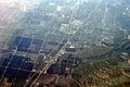 Aerial view of Edison from the east-northeast
 -
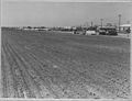 Potato farm in Edison, 1940


References
Wikimedia Commons has media related to Edison, California.
- ^ a b c U.S. Geological Survey Geographic Names Information System: Edison, California
- ^ "Edison CA ZIP Code". zipdatamaps.com. 2023. Retrieved February 17, 2023.
- ^ a b c d e Durham, David L. (1998). California's Geographic Names: A Gazetteer of Historic and Modern Names of the State. Clovis, Calif.: Word Dancer Press. p. 1031. ISBN 1-884995-14-4.
- ^ Kasline, Fred A. Edison Oil Field: California Division of Oil and Gas, Summary of Operations. 1940. Vol. 26 p 12-18
- ^ White, J. Lloyd. Edison Oil Field: California Division of Oil and Gas, Summary of Operations. 1955. Vol. 41 No. 2, p 5-9
- v
- t
- e
Municipalities and communities of Kern County, California, United States
County seat: Bakersfield
- Arvin
- Bakersfield
- California City
- Delano
- Maricopa
- McFarland
- Ridgecrest
- Shafter
- Taft
- Tehachapi
- Wasco

- Alta Sierra
- Bakersfield Country Club
- Bear Valley Springs
- Benton Park
- Bodfish
- Boron
- Buttonwillow
- Casa Loma
- Cherokee Strip
- China Lake Acres
- Choctaw Valley
- Cottonwood
- Derby Acres
- Di Giorgio
- Dustin Acres
- East Bakersfield
- East Niles
- Edison
- Edmundson Acres
- Edwards AFB
- El Adobe
- Fairfax
- Fellows
- Ford City
- Frazier Park
- Fuller Acres
- Glennville
- Goodmanville
- Golden Hills
- Greenacres
- Greenfield
- Hillcrest
- Inyokern
- Johannesburg
- Kernville
- La Cresta
- Lake Isabella
- Lake of the Woods
- Lakeside
- Lamont
- Lebec
- Lost Hills
- McKittrick
- Mettler
- Mexican Colony
- Mojave
- Mountain Meadows
- Mountain Mesa
- North Edwards
- Oildale
- Old River
- Old Stine
- Olde Stockdale
- Onyx
- Pine Mountain Club
- Potomac Park
- Pumpkin Center
- Randsburg
- Rexland Acres
- Ridgecrest Heights
- Rivergrove
- Rosamond
- Rosedale
- Smith Corner
- South Taft
- Squirrel Mountain Valley
- Stallion Springs
- Stebbins
- Taft Heights
- Tarina
- Tupman
- Valley Acres
- Weedpatch
- Weldon
- Wofford Heights
- Woody
communities
- Actis
- Aerial Acres
- Bealville
- Bena
- Blackwells Corner
- Caliente
- Canebrake
- Cantil
- Cawelo
- China Lake
- Claraville
- Desert Lake
- Edwards
- Famoso
- Fruitvale
- Grapevine
- Gypsite
- Havilah
- Indian Wells
- Keyesville
- Lerdo
- Loraine
- Midoil
- Minter Village
- Miracle Hot Springs
- Missouri Triangle
- Monolith
- North Shafter
- Oil City
- Old Town
- Panama
- Pentland
- Pinon Pines Estates
- Pond
- Reward
- Rio Bravo
- Riverkern
- Rowen
- Sageland
- Saltdale
- Sand Canyon
- South Lake
- Spicer City
- Thomas Lane
- Twin Oaks
- Wheeler Ridge
- Willow Springs
settlements
- California portal
- United States portal
 | This Kern County, California-related article is a stub. You can help Wikipedia by expanding it. |
- v
- t
- e


