Dez Dam
Dam in Khuzestan
32°36.3′N 48°27.8′E / 32.6050°N 48.4633°E / 32.6050; 48.4633dezdam
The Dez Dam (Persian: سد دز), formerly known as Mohammad-Reza Shah Pahlavi Dam (Persian: سد محمدرضا شاه پهلوی), before 1979 Revolution, is an arch dam on the Dez River in the southwestern province of Khuzestan, Iran. It was built between 1959 and 1963 during the rule of Mohammad Reza Pahlavi,the last Shah of Iran, with contacting an Italian consortium and is owned by the Khuzestan Water & Power Authority[3]. The dam is 203 metres (666 ft) high, making it one of the highest in the country, and has a reservoir capacity of 3,340,000,000 m3 (2,710,000 acre⋅ft). At the time of construction the Dez Dam was Iran's biggest development project. The primary purpose of the dam is hydroelectric power production and irrigation. It has an associated 520 MW power station and its reservoir helps irrigate up to 80,500 ha (199,000 acres) of farmland. US$42 million of the cost to construct the dam came from the World Bank.[4][5]
Background
Impregilo was involved with building the Dez Dam. Plans for the dam were finalized in 1957 and construction began in 1959. In 1962 the first generator was commissioned. In 1963 the dam was complete with two of the eight 65 MW Francis turbine generators commissioned. The remaining six were commissioned by 1970. In the late 1970s the irrigation of the project had reached 80,500 ha (199,000 acres) of its 110,000 ha (270,000 acres) goal.[4][5][6]
The dam's current problem is the annual loss of reservoir capacity due to the erosion of soil in upstream areas. By 2006, the reservoir volume was estimated to be 2,600,000,000 m3 (2,100,000 acre⋅ft)[7]
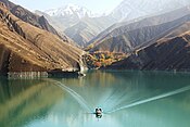
Gallery
-
 Aerial view of the Dez Reservoir

See also
References
- ^ "Dam and Reservoir Specification". Dez Dam Powerplant O&M Company (in Persian).
- ^ a b c d "New Page 1". www.khpimc.com. Archived from the original on July 13, 2011.
- ^ "Britannica Dez Dam". britannica.
- ^ a b "Hydroelectric Power Plants in Iran". IndustCards. Archived from the original on 8 September 2012. Retrieved 13 January 2015.
- ^ a b "The Dez Multipuropose Dam Project in Iran". San Jose State University. Retrieved 13 January 2015.
- ^ Ghazi, Iran (1977). The dez multi-purpose dam scheme, Khuzestan a socio-economic analysis (Doctoral). Durham University. Retrieved 13 January 2015.
- ^ Kiani, M. (May 2006). "Sedimentation Issues in the Dez Dam Reservoir" (PDF). The Role of Dams in the 21st Century. an Antonio River Authority: 409–411. Archived from the original (PDF) on 2015-10-05. Retrieved 2015-01-13.
External links
 Iran portal
 Water portal
 Renewable energy portal


![]() Media related to Dez Dam at Wikimedia Commons
Media related to Dez Dam at Wikimedia Commons
- v
- t
- e
Khuzestan Province, Iran

and cities
- Abadan's museum
- Gundishapur
- Acropole of Shush
- Apadana in Susa
- Arjan castle, Behbahan
- Asak ancient city, Hendijan
- Chagadom tappe fire temple
- Chogha Mish Proto-Elamite site
- Chogha Zanbil
- Dav o Dokhtar castle, Ramhormoz
- Dez Dam
- Eshkaft-e Salman
- Gargar bridge, Shushtar
- Haft Tepe
- Hoor-al-azim lagoon
- Imamzadeh Roudband, Dezful
- Imamzadeh Sabz-e-ghaba, Dezful
- Karkheh Dam
- Khorramshahr mosque, Battle of Khorramshahr
- Kul-e Farah
- lake of Karkheh dam
- Lake of Karun
- Lali bridge
- Meyangaran lagoon
- Rangooni's mosque
- Salasel castle, Shushtar
- Shadegan lagoon
- Shevi waterfall, Dezful
- Shush-Daniel
- Shushtar Historical Hydraulic System
- Shushtar Watermills
- Susa
- Shush Castle
- Taryana
- Tobiron valley, Dezful
- Tomb of Daniel, Shush
- White bridge, Ahvaz
- Ya'qub-i Laith's tomb, Dezful
| ||
|---|---|---|
| Major reservoirs and dams in Iran |
|  |
| Under construction | ||
| Ancient dams | ||
Also See: Dams and reservoirs in Iran | ||


