Damrak
Avenue in Amsterdam between Centraal and Dam Square
The Damrak is an avenue and partially filled in canal at the centre of Amsterdam, The Netherlands, running between Amsterdam Centraal in the north and Dam Square in the south. It is the main street where people arriving at the station enter the centre of the city. Also, it is one of the two GVB tram routes from the station into the centre, with lines 4, 9, 16, and 25 running down it. It is also on the route of the North/South Line (Amsterdam metro line) being constructed between the existing metro station at Centraal Station and the new Rokin station.
The street was located on a rak (reach), a straight part of the Amstel river near a dam; hence the name.[1] In the 19th century, a section of it was filled in.
Stock exchange
Because of the former stock exchange building, the monumental Beurs van Berlage,[2] and several other buildings related to financial activities erected there in the early 20th century, the term "Damrak" has come to be a synonym for the Amsterdam Stock Exchange in the same way "Wall Street" is synonymous with the New York Stock Exchange and NASDAQ.[citation needed] The Beurs van Berlage now serves as a concert and exhibition hall. Today, the area is known for its restaurants, bars, and tourist shops. Its canals serve as a busy area for canal boats, as well.[2]
Gallery
-
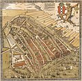 A birdseye view of Amsterdam circa 1544, looking south. The Damrak is the waterway at the center.
 -
 On the east side of the Damrak, the houses are located directly on the water, 2011
 -
 Typical architecture of the Damrak.


See also
References
Wikimedia Commons has media related to Damrak, Amsterdam.
- ^ "Damrak, Damrak nu" (in Dutch). Archived from the original on 2009-05-08. Retrieved 2007-10-07.
- ^ a b Martin Dunford (2010). The Rough Guide to The Netherlands. Penguin. pp. 62–63. ISBN 978-1-84836-882-8. Retrieved 24 November 2011.
- v
- t
- e
Canals of Amsterdam
Excludes former canals that have since been filled in
- Damrak (partly filled up)
- Rokin (partly filled up)
- Amstel

Authority control databases | |
|---|---|
| International |
|
| National |
|
52°22′34″N 4°53′50″E / 52.37611°N 4.89722°E / 52.37611; 4.89722


