Cucalón, Aragon
Place in Aragon, Spain
Flag

Coat of arms
(2018)[1]
Cucalón is a municipality located in the province of Teruel, Aragon, Spain. According to the 2010 census the municipality has a population of 102 inhabitants.[2] This town gives its name to the Sierra de Cucalón system of mountain ranges.
There are ruins of an ancient Iberian settlement, known as Peña el Castillo, located within Cucalón's municipal term.[3]
Gallery
-
 Street in Cucalón with the remains of Santiago church
 -
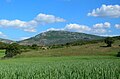 La Modorra, highest point in the Sierra de Cucalón system


See also
- Jiloca Comarca
- List of municipalities in Teruel
References
External links
Wikimedia Commons has media related to Cucalón.
- Cucalón, Jiloca[permanent dead link]
- Cucalón
- Sierra de Cucalón
- Guía general de las sierras de Cucalón, Oriche y Fonfría
- v
- t
- e
- Ababuj
- Abejuela
- Aguatón
- Aguaviva
- Aguilar del Alfambra
- Alacón
- Alba
- Albalate del Arzobispo
- Albarracín
- Albentosa
- Alcaine
- Alcalá de la Selva
- Alcañiz
- Alcorisa
- Alfambra
- Aliaga
- Allepuz
- Alloza
- Allueva
- Almohaja
- Alobras
- Alpeñés
- Anadón
- Andorra
- Arcos de las Salinas
- Arens de Lledó
- Argente
- Ariño
- Azaila
- Bádenas
- Báguena
- Bañón
- Barrachina
- Bea
- Beceite
- Bello
- Belmonte de San José
- Berge
- Bezas
- Blancas
- Blesa
- Bordón
- Bronchales
- Bueña
- Burbáguena
- Cabra de Mora
- Calaceite
- Calamocha
- Calanda
- Calomarde
- Camañas
- Camarena de la Sierra
- Camarillas
- Caminreal
- Cantavieja
- Cascante del Río
- Castejón de Tornos
- Castel de Cabra
- Castellote
- Castelnou
- Castelserás
- Cañada Vellida
- Cañada de Benatanduz
- Cañizar del Olivar
- Cedrillas
- Celadas
- Cella
- Corbalán
- Cortes de Aragón
- Cosa
- Cretas
- Crivillén
- Cubla
- Cucalón
- Cuevas Labradas
- Cuevas de Almudén
- Ejulve
- El Castellar
- El Cuervo
- El Pobo
- El Vallecillo
- Escorihuela
- Escucha
- Estercuel
- Ferreruela de Huerva
- Fonfría
- Formiche Alto
- Fortanete
- Foz-Calanda
- Frías de Albarracín
- Fuenferrada
- Fuentes Calientes
- Fuentes Claras
- Fuentes de Rubielos
- Fuentespalda
- Fórnoles
- Galve
- Gargallo
- Gea de Albarracín
- Griegos
- Guadalaviar
- Gúdar
- Hinojosa de Jarque
- Huesa del Común
- Híjar
- Jabaloyas
- Jarque de la Val
- Jatiel
- Jorcas
- Josa
- La Cañada de Verich
- La Cerollera
- La Codoñera
- La Cuba
- La Fresneda
- La Ginebrosa
- La Hoz de la Vieja
- La Iglesuela del Cid
- La Mata de los Olmos
- La Portellada
- La Puebla de Híjar
- La Puebla de Valverde
- La Zoma
- Lagueruela
- Lanzuela
- Las Parras de Castellote
- Libros
- Lidón
- Linares de Mora
- Lledó
- Los Olmos
- Loscos
- Maicas
- Manzanera
- Martín del Río
- Mas de las Matas
- Mazaleón
- Mezquita de Jarque
- Mirambel
- Miravete de la Sierra
- Molinos
- Monforte de Moyuela
- Monreal del Campo
- Monroyo
- Montalbán
- Monteagudo del Castillo
- Monterde de Albarracín
- Mora de Rubielos
- Moscardón
- Mosqueruela
- Muniesa
- Noguera de Albarracín
- Nogueras
- Nogueruelas
- Obón
- Odón
- Ojos Negros
- Olba
- Oliete
- Orihuela del Tremedal
- Orrios
- Palomar de Arroyos
- Pancrudo
- Peracense
- Peralejos
- Perales del Alfambra
- Peñarroya de Tastavins
- Pitarque
- Plou
- Pozondón
- Pozuel del Campo
- Puertomingalvo
- Rillo
- Riodeva
- Royuela
- Rubiales
- Rubielos de Mora
- Rubielos de la Cérida
- Ráfales
- Ródenas
- Salcedillo
- Saldón
- Samper de Calanda
- San Agustín
- San Martín del Río
- Santa Cruz de Nogueras
- Santa Eulalia del Campo
- Sarrión
- Segura de los Baños
- Seno
- Singra
- Terriente
- Teruel
- Toril y Masegoso
- Tormón
- Tornos
- Torralba de los Sisones
- Torre de Arcas
- Torre de las Arcas
- Torre del Compte
- Torre los Negros
- Torrecilla de Alcañiz
- Torrecilla del Rebollar
- Torrelacárcel
- Torremocha de Jiloca
- Torres de Albarracín
- Torrevelilla
- Torrijas
- Torrijo del Campo
- Tramacastiel
- Tramacastilla
- Tronchón
- Urrea de Gaén
- Utrillas
- Valacloche
- Valbona
- Valdealgorfa
- Valdecuenca
- Valdelinares
- Valdeltormo
- Valderrobres
- Valjunquera
- Veguillas de la Sierra
- Villafranca del Campo
- Villahermosa del Campo
- Villanueva del Rebollar de la Sierra
- Villar del Cobo
- Villar del Salz
- Villarluengo
- Villarquemado
- Villarroya de los Pinares
- Villastar
- Villel
- Vinaceite
- Visiedo
- Vivel del Río Martín

 | This article about a location in the Province of Teruel is a stub. You can help Wikipedia by expanding it. |
- v
- t
- e


