Croixrault
You can help expand this article with text translated from the corresponding article in French. (July 2012) Click [show] for important translation instructions.
- View a machine-translated version of the French article.
- Machine translation, like DeepL or Google Translate, is a useful starting point for translations, but translators must revise errors as necessary and confirm that the translation is accurate, rather than simply copy-pasting machine-translated text into the English Wikipedia.
- Do not translate text that appears unreliable or low-quality. If possible, verify the text with references provided in the foreign-language article.
- You must provide copyright attribution in the edit summary accompanying your translation by providing an interlanguage link to the source of your translation. A model attribution edit summary is
Content in this edit is translated from the existing French Wikipedia article at [[:fr:Croixrault]]; see its history for attribution. - You may also add the template
{{Translated|fr|Croixrault}}to the talk page. - For more guidance, see Wikipedia:Translation.
Commune in Hauts-de-France, France
Croixrault | ||
|---|---|---|
Commune | ||
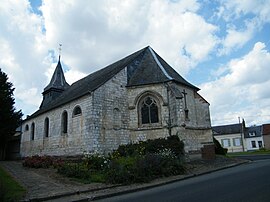 The church in Croixrault | ||
Location of Croixrault  | ||
(2020–2026) Didier Darsin[1] | | |
| Area 1 | 8.96 km2 (3.46 sq mi) | |
| Population (2021)[2] | 459 | |
| • Density | 51/km2 (130/sq mi) | |
| Time zone | UTC+01:00 (CET) | |
| • Summer (DST) | UTC+02:00 (CEST) | |
| INSEE/Postal code | 80227 /80290 | |
| Elevation | 111–187 m (364–614 ft) (avg. 183 m or 600 ft) | |
| 1 French Land Register data, which excludes lakes, ponds, glaciers > 1 km2 (0.386 sq mi or 247 acres) and river estuaries. | ||
Croixrault (French pronunciation: [kʁwaʁo]; Picard: Cloreu) is a commune in the Somme department in Hauts-de-France in northern France.
Geography
Croixrault is situated on the D341 and D141 crossroads, some 18 miles (29 km) southwest of Amiens.
The commune is served by exit 13 of the A29 freeway. This connects the old route of the former Route Nationale 1 with the former Route Nationale 29. The freeway also offers a service area. In 2019, Croixrault will be served by Trans'80 bus routes every day of the week, except Sundays and public holidays.
Population
| Year | Pop. | ±% p.a. |
|---|---|---|
| 1968 | 372 | — |
| 1975 | 351 | −0.83% |
| 1982 | 365 | +0.56% |
| 1990 | 356 | −0.31% |
| 1999 | 355 | −0.03% |
| 2007 | 414 | +1.94% |
| 2012 | 438 | +1.13% |
| 2017 | 434 | −0.18% |
| Source: INSEE[3] | ||
See also
References
- ^ "Répertoire national des élus: les maires". data.gouv.fr, Plateforme ouverte des données publiques françaises (in French). 2 December 2020.
- ^ "Populations légales 2021". The National Institute of Statistics and Economic Studies. 28 December 2023.
- ^ Population en historique depuis 1968, INSEE
Wikimedia Commons has media related to Croixrault.
- v
- t
- e
Communes of the Somme department
- Abbevillesubpr
- Ablaincourt-Pressoir
- Acheux-en-Amiénois
- Acheux-en-Vimeu
- Agenville
- Agenvillers
- Aigneville
- Ailly-le-Haut-Clocher
- Ailly-sur-Noye
- Ailly-sur-Somme
- Airaines
- Aizecourt-le-Bas
- Aizecourt-le-Haut
- Albert
- Allaines
- Allenay
- Allery
- Allonville
- Amienspref
- Andainville
- Andechy
- Argœuves
- Argoules
- Arguel
- Armancourt
- Arquèves
- Arrest
- Arry
- Arvillers
- Assainvillers
- Assevillers
- Athies
- Aubercourt
- Aubigny
- Aubvillers
- Auchonvillers
- Ault
- Aumâtre
- Aumont
- Autheux
- Authie
- Authieule
- Authuille
- Avelesges
- Aveluy
- Avesnes-Chaussoy
- Ayencourt
- Bacouel-sur-Selle
- Bailleul
- Baizieux
- Balâtre
- Barleux
- Barly
- Bavelincourt
- Bayencourt
- Bayonvillers
- Bazentin
- Béalcourt
- Beaucamps-le-Jeune
- Beaucamps-le-Vieux
- Beauchamps
- Beaucourt-en-Santerre
- Beaucourt-sur-l'Ancre
- Beaucourt-sur-l'Hallue
- Beaufort-en-Santerre
- Beaumetz
- Beaumont-Hamel
- Beauquesne
- Beauval
- Bécordel-Bécourt
- Becquigny
- Béhen
- Béhencourt
- Bellancourt
- Belleuse
- Belloy-en-Santerre
- Belloy-Saint-Léonard
- Belloy-sur-Somme
- Bergicourt
- Bermesnil
- Bernâtre
- Bernaville
- Bernay-en-Ponthieu
- Bernes
- Berneuil
- Berny-en-Santerre
- Bertangles
- Berteaucourt-les-Dames
- Berteaucourt-lès-Thennes
- Bertrancourt
- Béthencourt-sur-Mer
- Béthencourt-sur-Somme
- Bettembos
- Bettencourt-Rivière
- Bettencourt-Saint-Ouen
- Beuvraignes
- Biaches
- Biarre
- Biencourt
- Billancourt
- Blangy-sous-Poix
- Blangy-Tronville
- Boisbergues
- Le Boisle
- Boismont
- Bonnay
- Bonneville
- Bosquel
- Bouchavesnes-Bergen
- Bouchoir
- Bouchon
- Boufflers
- Bougainville
- Bouillancourt-en-Séry
- Bouillancourt-la-Bataille
- Bouquemaison
- Bourdon
- Bourseville
- Boussicourt
- Bouttencourt
- Bouvaincourt-sur-Bresle
- Bouvincourt-en-Vermandois
- Bouzincourt
- Bovelles
- Boves
- Braches
- Brailly-Cornehotte
- Brassy
- Bray-lès-Mareuil
- Bray-sur-Somme
- Breilly
- Bresle
- Breuil
- Brévillers
- Brie
- Briquemesnil-Floxicourt
- Brocourt
- Brouchy
- Brucamps
- Brutelles
- Buigny-l'Abbé
- Buigny-lès-Gamaches
- Buigny-Saint-Maclou
- Buire-Courcelles
- Buire-sur-l'Ancre
- Bus-la-Mésière
- Bus-lès-Artois
- Bussu
- Bussus-Bussuel
- Bussy-lès-Daours
- Bussy-lès-Poix
- Buverchy
- Cachy
- Cagny
- Cahon
- Caix
- Cambron
- Camon
- Camps-en-Amiénois
- Canaples
- Canchy
- Candas
- Cannessières
- Cantigny
- Caours
- Cappy
- Cardonnette
- Le Cardonnois
- Carnoy-Mametz
- Carrépuis
- Cartigny
- Caulières
- Cavillon
- Cayeux-en-Santerre
- Cayeux-sur-Mer
- Cerisy
- Cerisy-Buleux
- Champien
- Chaulnes
- La Chaussée-Tirancourt
- Chaussoy-Epagny
- La Chavatte
- Chépy
- Chilly
- Chipilly
- Chirmont
- Chuignes
- Chuignolles
- Citerne
- Cizancourt
- Clairy-Saulchoix
- Cléry-sur-Somme
- Cocquerel
- Coigneux
- Coisy
- Colincamps
- Combles
- Condé-Folie
- Contalmaison
- Contay
- Conteville
- Contre
- Conty
- Corbie
- Cottenchy
- Coullemelle
- Coulonvillers
- Courcelette
- Courcelles-au-Bois
- Courcelles-sous-Moyencourt
- Courcelles-sous-Thoix
- Courtemanche
- Cramont
- Crécy-en-Ponthieu
- Crémery
- Cressy-Omencourt
- Creuse
- Croix-Moligneaux
- Croixrault
- Le Crotoy
- Crouy-Saint-Pierre
- Curchy
- Curlu
- Damery
- Dancourt-Popincourt
- Daours
- Dargnies
- Davenescourt
- Démuin
- Dernancourt
- Devise
- Doingt
- Domart-en-Ponthieu
- Domart-sur-la-Luce
- Domesmont
- Dominois
- Domléger-Longvillers
- Dommartin
- Dompierre-Becquincourt
- Dompierre-sur-Authie
- Domqueur
- Domvast
- Doudelainville
- Douilly
- Doullens
- Dreuil-lès-Amiens
- Driencourt
- Dromesnil
- Drucat
- Dury
- Eaucourt-sur-Somme
- L'Échelle-Saint-Aurin
- Éclusier-Vaux
- Embreville
- Englebelmer
- Ennemain
- Épagne-Épagnette
- Épaumesnil
- Épécamps
- Épehy
- Épénancourt
- Éplessier
- Eppeville
- Équancourt
- Équennes-Éramecourt
- Erches
- Ercheu
- Ercourt
- Ergnies
- Érondelle
- Esclainvillers
- Esmery-Hallon
- Essertaux
- Estrébœuf
- Estrées-Deniécourt
- Estrées-lès-Crécy
- Estrées-Mons
- Estrées-sur-Noye
- Étalon
- Ételfay
- Éterpigny
- Étinehem-Méricourt
- L'Étoile
- Étréjust
- Étricourt-Manancourt
- La Faloise
- Falvy
- Famechon
- Faverolles
- Favières
- Fay
- Ferrières
- Fescamps
- Feuillères
- Feuquières-en-Vimeu
- Fieffes-Montrelet
- Fienvillers
- Fignières
- Fins
- Flaucourt
- Flers
- Flers-sur-Noye
- Flesselles
- Fleury
- Flixecourt
- Fluy
- Folies
- Folleville
- Fonches-Fonchette
- Fontaine-le-Sec
- Fontaine-lès-Cappy
- Fontaine-sous-Montdidier
- Fontaine-sur-Maye
- Fontaine-sur-Somme
- Forceville
- Forceville-en-Vimeu
- Forest-l'Abbaye
- Forest-Montiers
- Fort-Mahon-Plage
- Fossemanant
- Foucaucourt-en-Santerre
- Foucaucourt-Hors-Nesle
- Fouencamps
- Fouilloy
- Fouquescourt
- Fourcigny
- Fourdrinoy
- Framerville-Rainecourt
- Framicourt
- Francières
- Franleu
- Franqueville
- Fransart
- Fransu
- Fransures
- Franvillers
- Fréchencourt
- Frémontiers
- Fresnes-Mazancourt
- Fresnes-Tilloloy
- Fresneville
- Fresnoy-Andainville
- Fresnoy-au-Val
- Fresnoy-en-Chaussée
- Fresnoy-lès-Roye
- Fressenneville
- Frettecuisse
- Frettemeule
- Friaucourt
- Fricamps
- Fricourt
- Frise
- Friville-Escarbotin
- Frohen-sur-Authie
- Froyelles
- Frucourt
- Gamaches
- Gapennes
- Gauville
- Gentelles
- Gézaincourt
- Ginchy
- Glisy
- Gorenflos
- Gorges
- Goyencourt
- Grandcourt
- Grand-Laviers
- Gratibus
- Grattepanche
- Grébault-Mesnil
- Grivesnes
- Grivillers
- Grouches-Luchuel
- Gruny
- Guerbigny
- Gueschart
- Gueudecourt
- Guignemicourt
- Guillaucourt
- Guillemont
- Guizancourt
- Guyencourt-Saulcourt
- Guyencourt-sur-Noye
- Hailles
- Hallencourt
- Hallivillers
- Halloy-lès-Pernois
- Hallu
- Ham
- Le Hamel
- Hamelet
- Hancourt
- Hangard
- Hangest-en-Santerre
- Hangest-sur-Somme
- Harbonnières
- Hardecourt-aux-Bois
- Harponville
- Hattencourt
- Hautvillers-Ouville
- Havernas
- Hébécourt
- Hédauville
- Heilly
- Hem-Hardinval
- Hem-Monacu
- Hénencourt
- Herbécourt
- Hérissart
- Herleville
- Herly
- Hervilly
- Hesbécourt
- Hescamps
- Heucourt-Croquoison
- Heudicourt
- Heuzecourt
- Hiermont
- Hombleux
- Hornoy-le-Bourg
- Huchenneville
- Humbercourt
- Huppy
- Hypercourt
- Ignaucourt
- Inval-Boiron
- Irles
- Jumel
- Laboissière-en-Santerre
- Lachapelle
- Lafresguimont-Saint-Martin
- Lahoussoye
- Laleu
- Lamaronde
- Lamotte-Brebière
- Lamotte-Buleux
- Lamotte-Warfusée
- Lanchères
- Lanches-Saint-Hilaire
- Languevoisin-Quiquery
- Laucourt
- Laviéville
- Lawarde-Mauger-l'Hortoy
- Léalvillers
- Lesbœufs
- Liancourt-Fosse
- Licourt
- Liéramont
- Liercourt
- Ligescourt
- Lignières
- Lignières-Châtelain
- Lignières-en-Vimeu
- Lihons
- Limeux
- Liomer
- Long
- Longavesnes
- Longpré-les-Corps-Saints
- Longueau
- Longueval
- Longuevillette
- Louvencourt
- Louvrechy
- Lucheux
- Machiel
- Machy
- Mailly-Maillet
- Mailly-Raineval
- Maisnières
- Maison-Ponthieu
- Maison-Roland
- Maizicourt
- Malpart
- Marcelcave
- Marché-Allouarde
- Marchélepot-Misery
- Marestmontiers
- Mareuil-Caubert
- Maricourt
- Marieux
- Marlers
- Marquaix
- Marquivillers
- Martainneville
- Matigny
- Maucourt
- Maurepas
- Le Mazis
- Méaulte
- Méharicourt
- Meigneux
- Le Meillard
- Méneslies
- Méréaucourt
- Mérélessart
- Méricourt-en-Vimeu
- Méricourt-l'Abbé
- Mers-les-Bains
- Le Mesge
- Mesnil-Bruntel
- Mesnil-Domqueur
- Mesnil-en-Arrouaise
- Mesnil-Martinsart
- Mesnil-Saint-Georges
- Mesnil-Saint-Nicaise
- Métigny
- Mézerolles
- Mézières-en-Santerre
- Miannay
- Millencourt
- Millencourt-en-Ponthieu
- Miraumont
- Mirvaux
- Moislains
- Molliens-au-Bois
- Molliens-Dreuil
- Monchy-Lagache
- Mons-Boubert
- Monsures
- Montagne-Fayel
- Montauban-de-Picardie
- Montdidiersubpr
- Montigny-les-Jongleurs
- Montigny-sur-l'Hallue
- Montonvillers
- Morchain
- Morcourt
- Moreuil
- Morisel
- Morlancourt
- Morvillers-Saint-Saturnin
- Mouflers
- Mouflières
- Moyencourt
- Moyencourt-lès-Poix
- Moyenneville
- Muille-Villette
- Nampont
- Namps-Maisnil
- Nampty
- Naours
- Nesle
- Nesle-l'Hôpital
- Neslette
- Neufmoulin
- Neuilly-le-Dien
- Neuilly-l'Hôpital
- Neuville-au-Bois
- Neuville-Coppegueule
- La Neuville-lès-Bray
- La Neuville-Sire-Bernard
- Neuvillette
- Nibas
- Nouvion
- Noyelles-en-Chaussée
- Noyelles-sur-Mer
- Nurlu
- Occoches
- Ochancourt
- Ô-de-Selle
- Offignies
- Offoy
- Oisemont
- Oissy
- Oneux
- Oresmaux
- Oust-Marest
- Outrebois
- Ovillers-la-Boisselle
- Pargny
- Parvillers-le-Quesnoy
- Pendé
- Pernois
- Péronnesubpr
- Picquigny
- Piennes-Onvillers
- Pierregot
- Pissy
- Plachy-Buyon
- Le Plessier-Rozainvillers
- Pœuilly
- Poix-de-Picardie
- Ponches-Estruval
- Pont-de-Metz
- Ponthoile
- Pont-Noyelles
- Pont-Remy
- Port-le-Grand
- Potte
- Poulainville
- Pozières
- Prouville
- Prouzel
- Proyart
- Puchevillers
- Punchy
- Puzeaux
- Pys
- Quend
- Querrieu
- Le Quesne
- Le Quesnel
- Quesnoy-le-Montant
- Quesnoy-sur-Airaines
- Quevauvillers
- Quiry-le-Sec
- Quivières
- Raincheval
- Rainneville
- Ramburelles
- Rambures
- Rancourt
- Regnière-Écluse
- Remaisnil
- Remaugies
- Remiencourt
- Rethonvillers
- Revelles
- Ribeaucourt
- Ribemont-sur-Ancre
- Riencourt
- Rivery
- Rogy
- Roiglise
- Roisel
- Rollot
- Ronssoy
- Rosières-en-Santerre
- Rouvrel
- Rouvroy-en-Santerre
- Rouy-le-Grand
- Rouy-le-Petit
- Roye
- Rubempré
- Rubescourt
- Rue
- Rumigny
- Saigneville
- Sailly-Flibeaucourt
- Sailly-Laurette
- Sailly-le-Sec
- Sailly-Saillisel
- Sains-en-Amiénois
- Saint-Acheul
- Saint-Aubin-Montenoy
- Saint-Aubin-Rivière
- Saint-Blimont
- Saint-Christ-Briost
- Sainte-Segrée
- Saint-Fuscien
- Saint-Germain-sur-Bresle
- Saint-Gratien
- Saint-Léger-lès-Authie
- Saint-Léger-lès-Domart
- Saint-Léger-sur-Bresle
- Saint-Mard
- Saint-Maulvis
- Saint-Maxent
- Saint-Ouen
- Saint-Quentin-en-Tourmont
- Saint-Quentin-la-Motte-Croix-au-Bailly
- Saint-Riquier
- Saint-Sauflieu
- Saint-Sauveur
- Saint-Vaast-en-Chaussée
- Saint-Valery-sur-Somme
- Saisseval
- Saleux
- Salouël
- Sancourt
- Saulchoy-sous-Poix
- Sauvillers-Mongival
- Saveuse
- Senarpont
- Senlis-le-Sec
- Sentelie
- Seux
- Sorel
- Sorel-en-Vimeu
- Soues
- Sourdon
- Soyécourt
- Surcamps
- Suzanne
- Tailly
- Talmas
- Templeux-la-Fosse
- Templeux-le-Guérard
- Terramesnil
- Tertry
- Thennes
- Thézy-Glimont
- Thiepval
- Thieulloy-l'Abbaye
- Thieulloy-la-Ville
- Thièvres
- Thoix
- Thory
- Tilloloy
- Tilloy-Floriville
- Tincourt-Boucly
- Le Titre
- Tœufles
- Tours-en-Vimeu
- Toutencourt
- Le Translay
- Treux
- Trois-Rivières
- Tully
- Ugny-l'Équipée
- Vadencourt
- Vaire-sous-Corbie
- Valines
- Varennes
- Vauchelles-lès-Authie
- Vauchelles-lès-Domart
- Vauchelles-les-Quesnoy
- Vaudricourt
- Vauvillers
- Vaux-en-Amiénois
- Vaux-Marquenneville
- Vaux-sur-Somme
- Vecquemont
- Velennes
- Vercourt
- Vergies
- Vermandovillers
- Verpillières
- Vers-sur-Selle
- La Vicogne
- Vignacourt
- Villecourt
- Ville-le-Marclet
- Villeroy
- Villers-aux-Érables
- Villers-Bocage
- Villers-Bretonneux
- Villers-Campsart
- Villers-Carbonnel
- Villers-Faucon
- Villers-lès-Roye
- Villers-sous-Ailly
- Villers-sur-Authie
- Villers-Tournelle
- Ville-sur-Ancre
- Vironchaux
- Vismes
- Vitz-sur-Authie
- Voyennes
- Vraignes-en-Vermandois
- Vraignes-lès-Hornoy
- Vrély
- Vron
- Wargnies
- Warloy-Baillon
- Warlus
- Warsy
- Warvillers
- Wiencourt-l'Équipée
- Wiry-au-Mont
- Woignarue
- Woincourt
- Woirel
- Y
- Yaucourt-Bussus
- Yonval
- Yvrench
- Yvrencheux
- Yzengremer
- Yzeux
- pref: prefecture
- subpr: subprefecture
| Authority control databases: National |
|
|---|
This Arrondissement of Amiens geographical article is a stub. You can help Wikipedia by expanding it. |
- v
- t
- e


