Corrigasleggaun
Mountain in Wicklow, Ireland


Corrigasleggaun
Location in Ireland
Corrigasleggaun (Irish: Carraig na Sliogán, meaning 'Rock of the shells')[2] at 794 metres (2,605 ft), is the 35th–highest peak in Ireland on the Arderin scale,[3] and the 45th–highest peak on the Vandeleur-Lynam scale.[4][5] Corrigasleggaun is situated in the southwestern sector of the Wicklow Mountains range, and is part of the large massif of Lugnaquilla 925 metres (3,035 ft), Wicklow's highest mountain.[6] Corrigasleggaun lies at the head of the glen of the easterly flowing Carrawaystick River, which includes the scenic corrie lake of Kelly's Lough near its summit, and Carrawaystick Mountain at its base.[6][7] Corrigasleggaun also lies alongside Lugnaquilla's South Prison, from which the River Ow flows south to the Aghavannagh Bridge.[7]
Bibliography
- Fairbairn, Helen (2014). Dublin & Wicklow: A Walking Guide. Collins Press. ISBN 978-1848892019.
- MountainViews Online Database (Simon Stewart) (2013). A Guide to Ireland's Mountain Summits: The Vandeleur-Lynams & the Arderins. Collins Books. ISBN 978-1-84889-164-7.
- Dillion, Paddy (1993). The Mountains of Ireland: A Guide to Walking the Summits. Cicerone. ISBN 978-1852841102.
Gallery
-
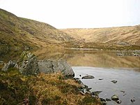 Kelly's Lough
 -
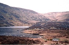
 View from summit to Carraystick River
 -
 Kelly's Lough, summit behind
 -
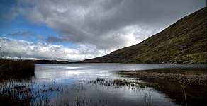 Kelly's Lough, looking east


See also
Wikimedia Commons has media related to Corrigasleggaun.
- Wicklow Way
- Wicklow Round
- Wicklow Mountains
- Lists of mountains in Ireland
- List of mountains of the British Isles by height
- List of Hewitt mountains in England, Wales and Ireland
References
- ^ a b c d "Corrigasleggaun". MountainViews Online Database. Retrieved 8 February 2019.
- ^ Paul Tempan (February 2012). "Irish Hill and Mountain Names" (PDF). MountainViews.ie.
- ^ Simon Stewart (October 2018). "Arderins: Irish mountains of 500+m with a prominence of 30m". MountainViews Online Database.
- ^ Simon Stewart (October 2018). "Vandeleur-Lynams: Irish mountains of 600+m with a prominence of 15m". MountainViews Online Database.
- ^ Mountainviews, (September 2013), "A Guide to Ireland's Mountain Summits: The Vandeleur-Lynams & the Arderins", Collins Books, Cork, ISBN 978-1-84889-164-7
- ^ a b Dillion, Paddy (1993). The Mountains of Ireland: A Guide to Walking the Summits. Cicerone. ISBN 978-1852841102.
Walk 10: Ballineddan Mountain, Slievemaan, Lugnaquillia, Camenabologue East Top, Camenabologue
- ^ a b Fairbairn, Helen (2014). Dublin & Wicklow: A Walking Guide. Collins Press. ISBN 978-1848892019.
External links
- MountainViews: The Irish Mountain Website, Corrigasleggaun
- MountainViews: Irish Online Mountain Database
- The Database of British and Irish Hills , the largest database of British Isles mountains ("DoBIH")
- Hill Bagging UK & Ireland, the searchable interface for the DoBIH
- v
- t
- e


 | This article related to the geography of County Wicklow, Ireland is a stub. You can help Wikipedia by expanding it. |
- v
- t
- e


