Comeragh Mountains
Mountain range in Ireland
| Comeragh Mountains | |
|---|---|
| Na Comaraigh | |
 Comeragh Mountains | |
| Highest point | |
| Peak | Fauscoum |
| Elevation | 792 m (2,598 ft) |
| Prominence | 622 m (2,041 ft) |
| Geography | |
| Location | County Waterford, Ireland |


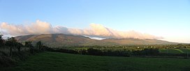
The Comeragh Mountains (Irish: Na Comaraigh) are a glaciated mountain range situated in southeast Ireland in County Waterford. They are located between the town of Dungarvan and stretch inland to the town of Clonmel on the County Tipperary border and the villages of Kilrossanty and Kilmacthomas in County Waterford.
The twelve mountains which form the Comeragh Mountains are popular for mountain climbers and hikers and the Comeragh Mountains Walking Festival is held every October and is centred on the Nire Valley.[1] The highest peak is Fauscoum at 792 m (2,598 ft).
References
- ^ "Comeragh Mountains- Muddy Boots". Fáilte Ireland. Archived from the original on 22 January 2021. Retrieved 9 January 2021.
External links
- Comeragh Mountaineering Club
- Listing at mountainviews.ie
- Dungarvan Tourism Official - Comeragh Mountain Walks
![]() Media related to Comeragh Mountains at Wikimedia Commons
Media related to Comeragh Mountains at Wikimedia Commons
52°17′N 7°34′W / 52.283°N 7.567°W / 52.283; -7.567
- v
- t
- e
Mountains and hills of Munster
- Carron Mountain
- Seefin

- Hungry Hill
- Sugarloaf (Slieve Gowl)
| Brandon Group | |
|---|---|
| Central Dingle | |
| Slieve Mish Mountains | |
| Western Dingle |
|
- Galtymore
- Lyracappul
- Temple Hill
- Knockmealdown
- Knocknafallia
- Sugarloaf Hill (Knockmealdowns)
| Authority control databases |
|
|---|


