Chaplin Estates
Neighbourhood in Toronto, Ontario, Canada
Chaplin Estates | |
|---|---|
Neighbourhood | |
 Lascelles Boulevard in Chaplin Estates | |
 | |
| Country | Canada |
| Province | Ontario |
| City | Toronto |
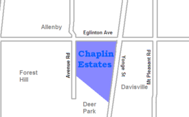
Chaplin Estates is a neighbourhood that covers the southwest portion of the Yonge and Eglinton area in Toronto, Ontario, Canada. It lies west of Yonge Street and is bounded by Eglinton Avenue to the north and Avenue Road to the west. The southern boundary is Chaplin Crescent, which runs parallel to the former Beltline Railway line, now the Beltline Trail, a scenic walking and biking trail.

A portion of the Toronto Transit Commission's Yonge-University-Spadina subway line runs above ground along the eastern fringe of Chaplin Estates, and transit access is provided through Davisville station and Eglinton station. Chaplin Estates is one of the wealthiest neighbourhoods in Toronto.
External links
- City of Toronto – Yonge-Eglinton Neighbourhood Profile
- Historic photos from around Chaplin Estates
Places adjacent to Chaplin Estates | ||||||||||||||||
|---|---|---|---|---|---|---|---|---|---|---|---|---|---|---|---|---|
| ||||||||||||||||


- v
- t
- e
Neighbourhoods in Toronto
- Alexandra Park
- Allenby
- The Annex
- The Beaches
- Bedford Park
- Bickford Park
- Bloor West Village
- Bloor Street Culture Corridor
- Bloordale Village
- Bracondale Hill
- Brockton Village
- Cabbagetown
- Carleton Village
- Casa Loma
- Chaplin Estates
- Chinatown (First Chinatown)
- Christie Pits
- Church and Wellesley
- CityPlace
- Corktown
- Corso Italia
- Corso Italia-Davenport
- Davenport
- Davisville Village
- Deer Park
- Discovery District
- Distillery District
- Downtown Yonge
- Dovercourt Park
- Dufferin Grove
- Earlscourt
- East Bayfront
- East Chinatown
- East Danforth
- East Toronto
- Entertainment District
- Fashion District
- Financial District
- Forest Hill
- Garden District
- Gerrard India Bazaar
- Grange Park
- Greektown
- Harbord Village
- Harbourfront
- High Park North
- The Junction
- Junction Triangle
- Kensington Market
- Koreatown
- Lawrence Park
- Leslieville
- Liberty Village
- Little Italy
- Little Portugal
- Little Tibet
- Lytton Park
- Midtown
- Moore Park
- Moss Park
- Niagara
- North Toronto
- Norway
- Old Town
- Palmerston
- Parkdale
- Playter Estates
- Port Lands
- Quayside
- Queen Street West
- Railway Lands
- Regent Park
- Riverdale
- Roncesvalles
- Rosedale
- Runnymede
- St. James Town
- St. Lawrence
- Seaton Village
- South Hill
- South Core
- Summerhill
- Swansea
- Toronto Islands
- Trefann Court
- Trinity-Bellwoods
- Upper Beaches
- Uptown Toronto
- Wallace Emerson
- The Ward
- West Don Lands (Canary District)
- Wychwood Park
- Yonge–Eglinton
- Yorkville
- Amesbury
- Armour Heights
- Bathurst Manor
- Bayview Village
- Bayview Woods-Steeles
- Bermondsey
- Bridle Path
- Clanton Park
- Don Mills
- Don Valley Village
- Downsview
- Flemingdon Park
- Glen Park
- Graydon Hall
- Henry Farm
- Hillcrest Village
- Hoggs Hollow
- Humber Summit
- Humbermede
- Jane and Finch
- Lansing
- Lawrence Heights
- Lawrence Manor
- Maple Leaf
- Newtonbrook
- North York City Centre
- Parkway Forest
- Parkwoods
- Pelmo Park-Humberlea
- Pleasant View
- Rustic
- Teddington Park
- Victoria Village
- Westminster-Branson
- Willowdale
- York Mills
- York University Heights
- Agincourt
- Armadale
- Bendale
- Birch Cliff
- Brown's Corners
- Clairlea
- Cliffcrest
- Cliffside
- Dorset Park
- Eglinton East
- Golden Mile
- Guildwood
- Highland Creek
- Ionview
- L'Amoreaux
- Malvern
- Maryvale
- Milliken
- Morningside
- Morningside Heights
- Oakridge
- Port Union
- Rouge
- Scarborough City Centre
- Scarborough Junction
- Scarborough Village
- Steeles
- Tam O'Shanter-Sullivan
- West Hill
- West Rouge
- Wexford
- Woburn
- Alderwood
- Clairville
- Eatonville
- The Elms
- Eringate-Centennial-West Deane
- Humber Heights-Westmount
- Humber Valley Village
- Humberwood
- Islington-City Centre West
- Kingsview Village
- The Kingsway
- Long Branch
- Markland Wood
- Mimico
- New Toronto
- Princess Gardens
- Rexdale
- Richview
- The Queensway-Humber Bay
- Smithfield
- Thistletown
- Thorncrest Village
Italics indicate neighbourhoods now defunct. For information on the evolution of each neighbourhood in general, see History of neighbourhoods in Toronto.
43°42′N 79°24′W / 43.70°N 79.40°W / 43.70; -79.40


