Cha Kwo Ling
Hill in Hong Kong

| Cha Kwo Ling | |||||||||||||
|---|---|---|---|---|---|---|---|---|---|---|---|---|---|
| Traditional Chinese | 茶果嶺 | ||||||||||||
| Simplified Chinese | 茶果岭 | ||||||||||||
| Cantonese Yale | chàh gwó léhng | ||||||||||||
| |||||||||||||
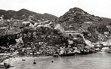

Cha Kwo Ling (Chinese: 茶果嶺) is a hill in the eastern New Kowloon area of Hong Kong, and the area around it. It is adjacent to Victoria Harbour and located to the west of Yau Tong and southwest of Lam Tin. Administratively, it belongs to the Kwun Tong District. The northeastern entrance to the Eastern Harbour Crossing is located in this area.
The Cha Kwo Ling Village (茶果嶺村), described as one of the last squatter villages in Hong Kong,[1] has a population of approximately 2,400. It is located approximately 1.4 km (0.87 mi) northwest of Lei Yue Mun, adjacent to the Laguna City development.[2] It lies at the foot of the hill and stretches along Cha Kwo Ling Road, which was built on reclaimed land and separates the village from the coast.[3] In the 2019 and 2020 policy addresses, the chief executive stated that the government intends to take back possession of the Cha Kwo Ling Village and to redevelop the land into high-density public housing.[4][5]
Cha Kwo Ling derives its name from the abundance of macaranga tanarius in the area, the leaves of which are used in the process of making cha kwo, a traditional Hakka snack.[6]
History

Cha Kwo Ling Village was established before Hong Kong became a British colony.[7] Cha Kwo Ling became a major Hakka settlement after the establishment of Victoria City in 1841. The foundation of city drew a large demand of stone. Skillful Hakka people set up a quarry in the stone-rich Cha Kwo Ling.[8] It was one of four quarry hills[9] and one of the 13 major village districts in eastern New Kowloon. The usage of new building materials later made the demand for stone drop. The population profile changed during the Civil War in China, when penniless refugees from mainland China settled in and around the original mining village, building makeshift shacks in a maze of dark alleys.[1] At its peak between the 1950s and the 1970s, the village had a population of about 20,000. Between 1983 and 2006, three big fires burned down many of the squatter houses and many villagers were relocated to public housing estates.[7]
Features


There is a Tin Hau Temple along Cha Kwo Ling Road, next to Cha Kwo Ling Village. Initially built near the coast in Cha Kwo Ling in 1825, during the Qing Dynasty, it was destroyed by a typhoon in 1912.[10] The image of Tin Hau was then transferred to a shack nearby and remained there for thirty years.[11] A new temple was built on the old site in 1941 with funds raised by the local villagers of Si Shan (四山, literally "four hills" composing four villages in the area, namely, Lei Yue Mun, Ngau Tau Kok, Sai Tso Wan and Cha Kwo Ling). However, the temple was demolished in 1947 to give way for the construction of an oil tank of Asiatic Petroleum Company (South China) Limited.[10] At the request of the local residents, a new temple was built at the present site.[10][11] The current temple opened officially in 1948. It has been managed by the Chinese Temples Committee since then.[12] The building is constructed of granite blocks, which is uncommon in Hong Kong. Its roofs have been covered with brown ceramic tiles in a 1999 renovation.[10]
Two rocks stand in front of the Tin Hau Temple. Shaped like two testicles, they have been named "Fung Shui Rocks", "Child-Giving Rocks" or "Stone of Fertility",[10] and are believed to bless those who pray to them for sons.[2]
Law Mansion (羅氏大屋), located at Nos. 50A, 51 & 51A Cha Kwo Ling Road, is a village house in the centre of Cha Kwo Ling Village. Constructed in 1855 of locally quarried granite, it is the oldest surviving residential building in Cha Kwo Ling.[3][13]
Education
Cha Kwo Ling is in Primary One Admission (POA) School Net 48. Within the school net are multiple aided schools (operated independently but funded with government money) and Kwun Tong Government Primary School.[14]
Transport
The nearest MTR stations are Lam Tin station and Yau Tong station. Minibus lines connect Cha Kwo Ling to the stations.[8]
References
- ^ a b Ng, June (13 May 2010). "Still Standing". HK Magazine. Archived from the original on 2011-01-29. Retrieved 17 July 2011.
- ^ a b "Fun in Kwun Tong - Heritage & Attractions". Archived from the original on 2009-03-13. Retrieved 2009-09-10.
- ^ a b Antiquities and Monuments Offices - Introduction to 1444 Historic Buildings, item No.1242 Archived October 13, 2012, at the Wayback Machine
- ^ "Policy Address". The Chief Executive's 2020 Policy Address. 25 November 2020. Retrieved 20 February 2021.
- ^ "LCQ2: Development plans for three squatter areas". Development Bureau. 3 June 2020. Retrieved 20 February 2021.
- ^ https://www.kwuntong.org.hk/publications/KTbook.pdf [bare URL PDF]
- ^ a b HK staff (13 May 2010). "The History of Cha Kwo Ling". HK Magazine. Archived from the original on 17 January 2013. Retrieved 17 July 2011.
- ^ a b Lei, Fu (13 December 2010). "Shantytowns face hard home truths". China Daily. Retrieved 17 July 2011.
- ^ Civil Engineering and Development Department, "Further Development of Tseung Kwan O. Feasibility Study. Environmental Impact Assessment. Chapter 13" July 2005
- ^ a b c d e Brief Information on No Grade Items, item No.1164 Archived 2012-10-15 at the Wayback Machine
- ^ a b Chinese Temples Committee: Tin Hau Temple, Cha Kwo Ling
- ^ Antiquities and Monuments Offices - Introduction to 1444 Historic Buildings, item No.1164 Archived October 13, 2012, at the Wayback Machine
- ^ Brief Information on No Grade Items, item No.1242 Archived 2012-10-15 at the Wayback Machine
- ^ "POA School Net 48" (PDF). Education Bureau. Retrieved 2022-09-12.
Further reading
- AECOM (October 2022). "Site Formation and Infrastructure Works for Public Housing Development at Cha Kwo Ling Village, Kowloon East – Investigation, Design and Construction. Heritage Impact Assessment (HIA) Report (Final) (Ref. A13-08)" (PDF). Antiquities Advisory Board. Civil Engineering and Development Department.
External links
Wikimedia Commons has media related to Cha Kwo Ling.
- RTHK: Hong Kong Connection. "茶果嶺的餘暉".
- RTHK: Hong Kong Connection. "茶果嶺的餘暉".
- RTHK: Hong Kong Connection. "茶果嶺的餘暉".
- v
- t
- e

- Sunset Peak
- The Hunch Backs
- Yin Ngam Teng
- Wo Tong Kong
- Grassy Hill
- Wong Leng
- Buffalo Hill
- West Buffalo Hill
- Kowloon Peak
- Shun Yeung Fung
- Tiu Shau Ngam
- Chau Ma Kong
- Middle Hill
- Lo Tin Teng
- Kai Kung Leng (Lam Tsuen)
- Castle Peak
- Lin Fa Shan (Tsuen Wan)
- Tate's Cairn
- Tai To Yan
- Wong Chuk Shan
- Victoria Peak
- Kwun Yam Shan (Yuen Long)
- Lai Pek Shan
- Tung Shan
- Chung Li Fung
- Shek Nga Shan
- Kau Nga Ling
- Pyramid Hill
- Tung Yeung Shan
- Needle Hill
- Mount Parker
- Kao Lao Fung
- Kuai Li Fung
- Pok To Yan
- Fu Yung Pit
- Hsien Ku Fung
- Sheung Tsz Fung
- Tsao Kau Fung
- Pak Tai To Yan
- Kau Keng Shan
- Mount Kellett
(excerpt)
- Lion Rock
- High West
- Sze Tsz Tau Shan
- Robin's Nest
- Ling Wui Shan
- Choi Wo Fung
- Hung Fa Chai
- Temple Hill
- Kwai Tau Leng
- Por Kai Shan
- Shek Uk Shan
- Muk Yue Shan
- Mount Gough
- Shek Lung Kung
- Sharp Peak
- Tai Hom Sham
- Wo Sheung Tung
- Lo Fu Tau
- Tin Fu Tsai Shan
- Keung Shan
- Beacon Hill
- Ngam Tau Shan
- Cheung Shan (Lantau Island)
- Cheung Yan Shan
- Cloudy Hill
- Mount Cameron
- Unicorn Ridge
- Mount Butler
- Kwun Yam Shan (Lantau)
- Violet Hill
- Jardine's Lookout
- Razor Hill
- Mount Nicholson
- Sham Hang Lek
- Middle Kau Nga Ling
- Siu Ma Shan
- Ngau Yee Shek Shan
- Tiu Tang Lung
- Luk Chau Shan
- Tai Cham Koi
- Luk Shan
(excerpt)
- Tai Sheung Tok
- Kai Kung Shan (Sai Kung)
- Kau To Shan
- Turret Hill
- Hebe Hill
- Wa Mei Shan
- The Twins South
- Lui Ta Shek
- Lau Fa Tung
- Yuen Tau Shan
- Nga Ying Shan
- Sugar Loaf Peak
- Kai Kung Shan (Lam Tsuen)
- Mount Hallowes
- Tai Mun Shan
- Golden Hill
- Fan Kei Tok
- Tin Mei Shan
- The Twins North
- Bird's Hill
- Cham Tin Shan
- Mount Stenhouse
- Mount Collinson
- Lower Hebe Hill
- High Junk Peak
- Cheung Lin Shan
- Shek Sze Shan
- Tsim Fung Shan
- Smuggler's Ridge
- Tsing Yi Peak
- Miu Tsai Tun
- D'Aguilar Peak
- Wo Liu Tun
- Sze Shan
- Tai Tun
- Sai Wan Shan (Sai Kung)
- Pottinger Peak
- Kwai Au Shan
- Eagle's Nest
- Black Hill
- Kwun Yam Tung
- Lo Yan Shan
- Tai Che Tung
- Tap Chai Shan
(excerpt)
- Tung Wan Shan
- Kung Um Shan
- Ma Tau Fung
- Tit Sze Kou
- Tai Leng Tung
- Tai Shan
- Brick Hill
- Shek O Peak
- Tai She Teng
- Tai Ngau Wu Teng
- Tin Ha Shan
- Fa Ping Teng
- Mount Davis
- Wan Cham Shan
- Ngau Wu Tun
- Kei Lak Chai
- Lung Fu Shan
- Ngo Sei Kai
- Sheung Yeung Shan
- Kwai Shan
- Ling Kok Shan
- Chiu Keng Wan Shan
- Tin Wan Shan
- Mau Wu Shan
- Bennet's Hill
- Tung Tau Teng
- Wang Tau Tun
- Nam Tong Teng
- Hung Heung Lo Fung
- Tai Yue Ngam Teng
- Piper's Hill
- Devil’s Peak
- Cheung Ngau Shan
- Kei Lun Shan
- San Sin Tseng Shan
- Tiu Chung Tai Shan
- Ping Tok Hang Shan
- Fa Shan
- Pai Tau Tun
- Cheung Ngau Shan
- Braemar Hill
- Boa Vista
- Pak Kok Shan
(excerpt)
- Sai Wan Shan (Chai Wan)
- Mount Johnston
- Crow's Nest
- Ping Shan
- Tai Yam Teng
- Shum Wan Shan
- Sha Tin Heights
- Cheung Shan (North District)
- Obelisk Hill
- Hammer Hill
- Cheung Shan (Sai Kung)
- Tai Ling (North District)
- Ho Hok Shan
- Fake Yuk Kwai Shan
- Siu Lam Hill
- Shouson Hill
- Ngai Tau
- Red Hill
- To Fung Shan
- Po Keng Teng
- Chung Hom Shan
- Cheung Pai Tun
- Kai Shan
- Kai Kung Leng (Kat O)
- Por Lo Shan
- Hung Tang Shan
- Crest Hill
- Duckling Hill
- Red Light Hill
(excerpt)
- Checkerboard Hill
- Pak Fu Shan
- Finger Hill
- Wong Shek
- Garden Hill
- Woh Chai Shan
- Diamond Hill
- Scenic Hill
- Pak Hok Shan
- Fu Shan
- Lo Shue Leng
- Yuen Chau Kok
- Cha Kwo Ling
- Tai Tseng Shan
- Duke's Hill
- Ko Po Shan
- Chu Wong Ling
- King's Park Hill
- Signal Hill
- Crocodile Hill
- Kadoorie Hill
- Sai Shan
- Observatory Hill
- Lung Shan (Ngau Tau Kok)
- Hok Ngam Teng
- Leighton Hill
- Quarry Hill
- Hung Hom Hill
- Lo Lung Hang Hill
- Shan Pui Leng
- Pak Fa Leng
- Mount Parish
- Mount Shadwell
- Caroline Hill
- Hong Kong Three Sharp Peaks
- Sai Kung Three Sharp Peaks
- Dragon's Back
- Eight Mountains of Kowloon
- Mini Pat Sin
- 4 Hills of Kowloon
- The Twins
- Pat Sin Leng
- Wong Leng
- Castle Peak Hinterland
- Four Guardian Beasts of Tai O
- Kai Kung Leng (Lam Tsuen)
22°18′13″N 114°13′52″E / 22.3037°N 114.231°E / 22.3037; 114.231


