Burnt Island, Isles of Scilly
Uninhabited island in Isles of Scilly, Cornwall, UK
49°53′44″N 6°21′14″W / 49.89556°N 6.35389°W / 49.89556; -6.35389
United Kingdom
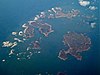
Burnt Island is a small, uninhabited island in the Isles of Scilly, Cornwall, United Kingdom. It is covered in thrift and long grasses.[1] and is linked to the island of St Agnes at low tide. It is approximately 150 metres long and 125 metres wide and is oblong in shape.[2]
As of 2014, Burnt Island had a geocache.[3]
References
 Cornwall portal

- ^ Kilda, St (1 April 2014). "A lifetime of Islands: Island 212 - Burnt Island, St Agnes, Isles of Scilly". A lifetime of Islands. Retrieved 8 September 2020.
- ^ "OS Maps: online mapping and walking, running and cycling routes". osmaps.ordnancesurvey.co.uk. Retrieved 8 September 2020.
- ^ Kilda, St (1 April 2014). "A lifetime of Islands: Island 212 - Burnt Island, St Agnes, Isles of Scilly". A lifetime of Islands. Retrieved 8 September 2020.
49°53′44″N 6°21′14″W / 49.8956°N 6.3540°W / 49.8956; -6.3540
- v
- t
- e
Isles of Scilly
- St Mary's
- St Agnes (and Gugh)
- Bryher
- Tresco
- St Martin's
- Annet
- Bishop Rock
- Crim Rocks
- Eastern Isles
- English Island
- Great Ganilly
- Gweal
- Norrard Rocks
- Pednathise Head
- Rosevear
- Round Island
- Samson
- St Helen's
- Teän
- Western Rocks
- White Island
- Zantman's Rock
- St Mary's: Hugh Town, Holy Vale, Longstone, Maypole, Normandy, Old Town, Pelistry, Porthloo, Rocky Hill, Telegraph and Trenoweth
- St Martin's: Higher Town, Middle Town and Lower Town
- St Agnes: Middle Town
- Tresco: New Grimsby and Old Grimsby
- Environment
- History
- People
- Transport
 | This article about a location in the Isles of Scilly, Cornwall is a stub. You can help Wikipedia by expanding it. |
- v
- t
- e


