Bara Tehsil
Tehsil in Khyber Pakhtunkhwa, Pakistan
Bara تحصیل باڑہ باړه تحصیل | |
|---|---|
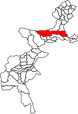 Location of Bara Tehsil in the Federally Administered Tribal Areas | |
| Country |  Pakistan Pakistan |
| Region |  Khyber Pakhtunkhwa Khyber Pakhtunkhwa |
| District | Khyber District |
| Headquarters | Bara |
| Government | |
| • Chairman | Mufti Muhammad Kafeel (JUI(F)) |
| • Assistance Political Agent | Ismatullah Wazir |
| Population (2017)[3] | |
| • Total | 444,403 |
| Time zone | UTC+5 (PST) |
Bara Tehsil (Urdu: باڑہ) is a subdivision located in Khyber District, Khyber Pakhtunkhwa, Pakistan.
Geography
Adjacent administrative units
- Nazyan District, Nangarhar Province, Afghanistan (north)
- Landi Kotal Tehsil (north)
- Jamrud Tehsil (northeast)
- Peshawar Tehsil, Peshawar District, Khyber Pakhtunkhwa (east)
- Frontier Region Kohat (southeast)
- Lower Orakzai Tehsil, Orakzai Agency (south)
- Central Orakzai Tehsil, Orakzai Agency (south)
- Upper Orakzai Tehsil, Orakzai Agency (southwest)
- Central Kurram Tehsil, Kurram Agency (west)
- Haska Meyna District, Nangarhar Province, Afghanistan (northwest)
- Achin District, Nangarhar Province, Afghanistan (northwest)
Demographics
| Year | Pop. | ±% |
|---|---|---|
| 1972 | 242,315 | — |
| 1981 | 142,501 | −41.2% |
| 1998 | 286,184 | +100.8% |
| 2017 | 444,403 | +55.3% |
| [4][3] | ||
Bara Tehsil has a population of 444,403 and has 51,869 households according to the 2017 census.[3]
Education
There are about 400 schools and colleges in Bara Tehsil. A total of 102 schools have been destroyed during a ten-year-long period of militancy in the region, and around 64,000 students have abandoned education.[5]
Transportation
Bara Tehsil is linked to Peshawar by the Peshawar-Bara road. Peshawar-Bara road was closed from 2009 to 2013 in an operation to contain growing militancy.[6]
See also
References
- ^ "Survey Of Damaged Houses Relaunched In Bara Tehsil". Pakistan Point. 2017-05-30. Retrieved 2018-05-11.
- ^ "Tribesmen hold peace seminar in Bara". The Frontier Post. Peshawar, Pakistan. 2018-01-24. Retrieved 2018-05-11.
- ^ a b c "DISTRICT AND TEHSIL LEVEL POPULATION SUMMARY WITH REGION BREAKUP [PDF]" (PDF). Pakistan Bureau of Statistics. 2018-01-03. Archived from the original (PDF) on 2018-03-26. Retrieved 2018-03-28.
- ^ "AREA & POPULATION OF ADMINISTRATIVE UNITS BY RURAL/URBAN: 1951-1998 CENSUSES" (PDF). Pakistan Bureau of Statistics. Retrieved 2018-05-11.
- ^ Pirzada, Ashrafuddin (2015-02-23). "After a decade of militancy, schools reopening in Bara". News Lens Pakistan. Retrieved 2018-05-11.
- ^ "Peshawar-Bara road opened after four years of closure". Business Recorder. Karachi, Pakistan. 2013-08-04. Retrieved 2018-05-11.
33°55′N 71°28′E / 33.917°N 71.467°E / 33.917; 71.467
- v
- t
- e
Tehsils of Khyber Pakhtunkhwa| Bannu |
|
|---|---|
| Lakki Marwat |
|
| North Waziristan |
| Dera Ismail Khan |
|
|---|---|
| Lower South Waziristan | |
| Upper South Waziristan | |
| Tank |
| Abbottabad |
|
|---|---|
| Batagram | |
| Haripur | |
| Kolai-Palas | |
| Lower Kohistan |
|
| Mansehra | |
| Tor Ghar | |
| Upper Kohistan |
| Hangu | |
|---|---|
| Karak | |
| Kohat |
|
| Kurram | |
| Orakzai |
| Bajaur | |
|---|---|
| Buner |
|
| Lower Chitral |
|
| Lower Dir | |
| Malakand |
|
| Shangla | |
| Swat | |
| Upper Chitral | |
| Upper Dir |
| Mardan |
|
|---|---|
| Swabi |
| Charsadda | |
|---|---|
| Khyber |
|
| Mohmand | |
| Nowshera | |
| Peshawar |
|
 | This Khyber District location article is a stub. You can help Wikipedia by expanding it. |
- v
- t
- e


