Bajung
Village development committee in Dhawalagiri Zone, Nepal
Bajung बाजुङ | |
|---|---|
Village development committee | |
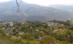 A view of Bajung from Bajung Kot | |
28°17′N 83°43′E / 28.28°N 83.71°E / 28.28; 83.71 | |
| Country |  Nepal Nepal |
| Zone | Dhawalagiri Zone |
| District | Parbat District |
| Population (2011) | |
| • Total | 4,228 (Male−1,806 & Female−2,422) |
| Time zone | UTC+5:45 (Nepal Time) |
| Area code | 067 |

Bajung is a village development committee in Parbat District in the Dhawalagiri Zone of Western Development Region, Nepal. It is surrounded by Deupurkot to the north-east, Tilahar to the south-east, Durlung to the south-west and Kyang to the north-west. It is popularly said to be extended from the top of Maidan, a hill-top with historical identity to the basin of Modi River. At the time of the 2011 Nepal census it had a population of 4228 people living in 1,076 individual households.
Like all VDCs of Nepal, it comprises nine wards:
- Ward 1: Patichaur (पातीचौर),
- Ward 2: Bause (बाऊसे),
- Ward 3: Sanopakha (सानोपाखा),
- Ward 4: Shivalaya (शिवालय),
- Ward 5: Bhaththar (भत्थर),
- Ward 6: Bardeghar (बर्देघर),
- Ward 7: Falhalne (फलहाल्ने),
- Ward 8: Laampaat (लाम्पट),
- Ward 9: Kalimati (कालीमाटी)[1][2]
References
- ^ "Nepal Census 2001", Nepal's Village Development Committees, Digital Himalaya, archived from the original on 12 October 2008, retrieved 15 November 2009.
- ^ http://cbs.gov.np/image/data/Population/VDC-Municipality%20in%20detail/44%20Parbat_VDCLevelReport.pdf Archived 2016-07-18 at the Wayback Machine | Government of Nepal National Planning Commission Secretariat Central Bureau of Statistics
External links
- UN map of the municipalities of Parbat District
- Government of Nepal National Planning Commission Secretariat Central Bureau of Statistics
- v
- t
- e
Parbat District
Headquarters: Kushma

- Arthar Dadakharka
- Bachchha
- Bahaki Thanti
- Bajung
- Balakot
- Banau
- Baskharka
- Behulibans
- Bhangara
- Bhoksing
- Bhorle
- Bhuk Deurali
- Bhuktangle
- Bihadi Barachaur
- Bihadi Ranipani
- Bitalawa Pipaltari
- Chitre
- Deupurkot
- Deurali
- Devisthan
- Dhairing
- Phalamkhani
- Phalebas Devisthan
- Phalebas Khanigaun
- Hosrangdi
- Huwas
- Karkineta
- Khaula Lakuri
- Kurgha
- Kushma
- Kyang
- Lekhphant
- Limithana
- Lunkhu Deurali
- Mallaj Majhphant
- Mudikuwa
- Nagliwang
- Pakhapani
- Pangrang
- Ramja Deurali
- Saligram
- Salija
- Saraukhola
- Shankar Pokhari
- Taklak
- Tanglekot
- Thana Maulo
- Thapathana
- Thuli Pokhari
- Tilahar
- Tribeni
- Urampokhara
 | This article about a location in Parbat District, Nepal is a stub. You can help Wikipedia by expanding it. |
- v
- t
- e


