Bắc Yên district
You can help expand this article with text translated from the corresponding article in Vietnamese. (March 2009) Click [show] for important translation instructions.
- View a machine-translated version of the Vietnamese article.
- Machine translation, like DeepL or Google Translate, is a useful starting point for translations, but translators must revise errors as necessary and confirm that the translation is accurate, rather than simply copy-pasting machine-translated text into the English Wikipedia.
- Do not translate text that appears unreliable or low-quality. If possible, verify the text with references provided in the foreign-language article.
- You must provide copyright attribution in the edit summary accompanying your translation by providing an interlanguage link to the source of your translation. A model attribution edit summary is
Content in this edit is translated from the existing Vietnamese Wikipedia article at [[:vi:Bắc Yên (huyện)]]; see its history for attribution. - You may also add the template
{{Translated|vi|Bắc Yên (huyện)}}to the talk page. - For more guidance, see Wikipedia:Translation.
District in Northwest, Vietnam
Bắc Yên district Huyện Bắc Yên | |
|---|---|
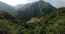 Panoramic view of Ban Phuc | |
| Country |  Vietnam Vietnam |
| Region | Northwest |
| Province | Sơn La |
| Capital | Bắc Yên |
| Area | |
| • Total | 419 sq mi (1,085 km2) |
| Population (2003) | |
| • Total | 48,877 |
| Time zone | UTC+7 (UTC + 7) |
Bắc Yên is a rural district of Sơn La province in the Northwest region of Vietnam. As of 2003, the district had a population of 48,877.[1] The district covers an area of 1,085 km2. The district capital lies at Bắc Yên.[1]
Climate
| Climate data for Bắc Yên | |||||||||||||
|---|---|---|---|---|---|---|---|---|---|---|---|---|---|
| Month | Jan | Feb | Mar | Apr | May | Jun | Jul | Aug | Sep | Oct | Nov | Dec | Year |
| Mean daily maximum °C (°F) | 18.9 (66.0) | 21.2 (70.2) | 24.7 (76.5) | 28.6 (83.5) | 30.0 (86.0) | 30.0 (86.0) | 29.6 (85.3) | 29.3 (84.7) | 28.2 (82.8) | 26.0 (78.8) | 23.2 (73.8) | 20.1 (68.2) | 25.8 (78.4) |
| Daily mean °C (°F) | 14.2 (57.6) | 15.8 (60.4) | 19.0 (66.2) | 22.6 (72.7) | 24.6 (76.3) | 25.4 (77.7) | 25.1 (77.2) | 24.7 (76.5) | 23.7 (74.7) | 21.6 (70.9) | 18.4 (65.1) | 15.1 (59.2) | 20.9 (69.6) |
| Mean daily minimum °C (°F) | 11.6 (52.9) | 13.0 (55.4) | 15.9 (60.6) | 19.1 (66.4) | 21.4 (70.5) | 22.6 (72.7) | 22.4 (72.3) | 22.1 (71.8) | 21.0 (69.8) | 18.7 (65.7) | 15.5 (59.9) | 12.2 (54.0) | 18.0 (64.4) |
| Average precipitation mm (inches) | 30.4 (1.20) | 22.6 (0.89) | 49.7 (1.96) | 111.1 (4.37) | 196.6 (7.74) | 241.5 (9.51) | 264.2 (10.40) | 271.3 (10.68) | 167.9 (6.61) | 76.4 (3.01) | 30.9 (1.22) | 22.3 (0.88) | 1,481.9 (58.34) |
| Average rainy days | 5.8 | 5.2 | 7.0 | 12.2 | 16.5 | 17.2 | 19.8 | 19.5 | 13.0 | 9.8 | 5.9 | 3.9 | 135.2 |
| Average relative humidity (%) | 83.1 | 81.2 | 79.6 | 79.1 | 78.8 | 82.3 | 84.7 | 85.7 | 84.1 | 82.2 | 80.3 | 79.1 | 81.7 |
| Mean monthly sunshine hours | 125.1 | 129.1 | 151.0 | 179.7 | 195.8 | 157.7 | 162.5 | 160.6 | 161.6 | 156.1 | 150.0 | 154.2 | 1,882.4 |
| Source: Vietnam Institute for Building Science and Technology[2] | |||||||||||||
References
- ^ a b "Districts of Vietnam". Statoids. Archived from the original on 1 March 2009. Retrieved March 13, 2009.
- ^ "Vietnam Institute for Building Science and Technology" (PDF). Retrieved 16 August 2023.
21°15′00″N 104°25′01″E / 21.250°N 104.417°E / 21.250; 104.417
- v
- t
- e
Districts of Northwest Vietnam

※ denotes provincial seat.
 | This article about a location in Sơn La Province, Vietnam is a stub. You can help Wikipedia by expanding it. |
- v
- t
- e


