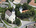
Bánhorváti
Village in Northern Hungary, Hungary

Flag

Coat of arms
(1 January 2023)[1]
3642
Bánhorváti is a village in Borsod-Abaúj-Zemplén county, Hungary. It appeared after Bánfalva and Bánhorvát merged in 1950.

In the 19th and 20th centuries, a small Jewish community lived in the village, in 1910 56 Jews lived in the village,[2] most of whom were murdered in the Holocaust.[3] The community had a Jewish cemetery.[4]
References
- ^ Detailed Gazetteer of Hungary. 30 October 2023 https://www.ksh.hu/apps/hntr.telepules?p_lang=EN&p_id=25159. Retrieved 5 November 2023.
{{cite web}}: Missing or empty|title=(help) - ^ Hungarian Jewish census
- ^ Documentation of the village's Jews murdered in the Holocaust
- ^ Banhorvati Jewish cemetery
External links
- Official webpage of Bánhorváti
- Street map Archived 1 October 2007 at the Wayback Machine (in Hungarian)
- v
- t
- e
- Miskolc (county seat)


- Abaújalpár
- Abaújkér
- Abaújlak
- Abaújszolnok
- Abaújvár
- Abod
- Aggtelek
- Alacska
- Alsóberecki
- Alsódobsza
- Alsógagy
- Alsóregmec
- Alsószuha
- Alsótelekes
- Alsóvadász
- Arka
- Arnót
- Aszaló
- Ároktő
- Baktakék
- Balajt
- Baskó
- Bánhorváti
- Bánréve
- Becskeháza
- Bekecs
- Berente
- Beret
- Berzék
- Bodroghalom
- Bodroghalász
- Bodrogkeresztúr
- Bodrogkisfalud
- Bodrogolaszi
- Bogács
- Boldogkőújfalu
- Boldogkőváralja
- Boldva
- Borsodbóta
- Borsodgeszt
- Borsodivánka
- Borsodszentgyörgy
- Borsodszirák
- Bódvalenke
- Bódvarákó
- Bódvaszilas
- Bózsva
- Bőcs
- Bükkaranyos
- Bükkábrány
- Bükkmogyorósd
- Bükkszentkereszt
- Bükkzsérc
- Büttös
- Csenyéte
- Cserépfalu
- Cserépváralja
- Csernely
- Csincse
- Csobaj
- Csobád
- Csokvaomány
- Damak
- Dámóc
- Debréte
- Dédestapolcsány
- Detek
- Domaháza
- Dövény
- Dubicsány
- Egerlövő
- Égerszög
- Erdőbénye
- Erdőhorváti
- Fáj
- Fancsal
- Farkaslyuk
- Felsőberecki
- Felsődobsza
- Felsőgagy
- Felsőkelecsény
- Felsőnyárád
- Felsőregmec
- Felsőtelekes
- Felsővadász
- Filkeháza
- Fony
- Forró
- Fulókércs
- Füzér
- Füzérkajata
- Füzérkomlós
- Füzérradvány
- Gadna
- Gagyapáti
- Gagybátor
- Gagyvendégi
- Galvács
- Garadna
- Gelej
- Gesztely
- Gibárt
- Girincs
- Golop
- Gömörszőlős
- Göncruszka
- Györgytarló
- Halmaj
- Hangács
- Hangony
- Harsány
- Háromhuta
- Hegymeg
- Hejce
- Hejőbába
- Hejőkeresztúr
- Hejőkürt
- Hejőpapi
- Hejőszalonta
- Hercegkút
- Hernádbűd
- Hernádcéce
- Hernádkak
- Hernádkércs
- Hernádnémeti
- Hernádpetri
- Hernádszentandrás
- Hernádszurdok
- Hernádvécse
- Hét
- Hidasnémeti
- Hidvégardó
- Hollóháza
- Homrogd
- Igrici
- Imola
- Ináncs
- Irota
- Jákfalva
- Járdánháza
- Jósvafő
- Kács
- Karcsa
- Karos
- Kánó
- Kány
- Kázsmárk
- Kelemér
- Kenézlő
- Keresztéte
- Kesznyéten
- Kéked
- Királd
- Kiscsécs
- Kisgyőr
- Kishuta
- Kiskinizs
- Kisrozvágy
- Kissikátor
- Kistokaj
- Komjáti
- Komlóska
- Kondó
- Korlát
- Kovácsvágás
- Köröm
- Krasznokvajda
- Kupa
- Kurityán
- Lak
- Lácacséke
- Ládbesenyő
- Legyesbénye
- Léh
- Lénárddaróc
- Litka
- Mád
- Makkoshotyka
- Mályi
- Martonyi
- Mályinka
- Megyaszó
- Meszes
- Mezőnagymihály
- Mezőnyárád
- Mezőzombor
- Méra
- Mikóháza
- Mogyoróska
- Monaj
- Monok
- Muhi
- Nagybarca
- Nagycsécs
- Nagyhuta
- Nagykinizs
- Nagyrozvágy
- Négyes
- Nekézseny
- Nemesbikk
- Novajidrány
- Nyésta
- Nyíri
- Nyomár
- Olaszliszka
- Ormosbánya
- Oszlár
- Ónod
- Pamlény
- Parasznya
- Pácin
- Pányok
- Pere
- Perecse
- Perkupa
- Prügy
- Pusztafalu
- Pusztaradvány
- Radostyán
- Ragály
- Rakaca
- Rakacaszend
- Rásonysápberencs
- Rátka
- Regéc
- Répáshuta
- Révleányvár
- Rudolftelep
- Sajóecseg
- Sajógalgóc
- Sajóhídvég
- Sajóivánka
- Sajókápolna
- Sajókaza
- Sajókeresztúr
- Sajólád
- Sajólászlófalva
- Sajómercse
- Sajónémeti
- Sajóörös
- Sajópálfala
- Sajópetri
- Sajópüspöki
- Sajósenye
- Sajószöged
- Sajóvámos
- Sajóvelezd
- Sály
- Sárazsadány
- Sáta
- Selyeb
- Semjén
- Serényfalva
- Sima
- Sóstófalva
- Szakácsi
- Szakáld
- Szalaszend
- Szalonna
- Szászfa
- Szegi
- Szegilong
- Szemere
- Szendrőlád
- Szentistvánbaksa
- Szin
- Szinpetri
- Szomolya
- Szögliget
- Szőlősardó
- Szuhafő
- Szuhakálló
- Szuhogy
- Taktabáj
- Taktakenéz
- Taktaszada
- Tarcal
- Tard
- Tállya
- Telkibánya
- Teresztenye
- Tibolddaróc
- Tiszabábolna
- Tiszacsermely
- Tiszadorogma
- Tiszakarád
- Tiszakeszi
- Tiszaladány
- Tiszapalkonya
- Tiszatardos
- Tiszatarján
- Tiszavalk
- Tolcsva
- Tomor
- Tornabarakony
- Tornakápolna
- Tornanádaska
- Tornaszentandrás
- Tornaszentjakab
- Tornyosnémeti
- Trizs
- Újcsanálos
- Uppony
- Vadna
- Vajdácska
- Varbó
- Varbóc
- Vatta
- Vágáshuta
- Vámosújfalu
- Vilmány
- Vilyvitány
- Viss
- Viszló
- Vizsoly
- Zalkod
- Zádorfalva
- Zemplénagárd
- Ziliz
- Zsujta
- Zubogy
 | This Borsod-Abaúj-Zemplén location article is a stub. You can help Wikipedia by expanding it. |
- v
- t
- e


