Apolima Strait
Strait in Western Samoa

The Apolima Strait is about 13 km[1] wide and separates the two largest islands of Samoa: Savai'i to the northwest, and Upolu to the southeast.
Three small islands lie in the strait. Two of them, Manono and Apolima, have small village settlements. Manono is about 3 miles off the west coast of Upolu. Apolima lies near the middle of the strait. The third, Nu'ulopa is a tiny, uninhabited, rocky outcrop with palm trees, which is surrounded by a natural turtle habitat islet.[2]
The main means of transportation between the two larger islands - passenger and vehicle ferries operated by the Samoa government - run through the strait between Mulifanua wharf on Upolu and Salelologa wharf on Savai'i.
The ferry crossing takes about 90 minutes.
Gallery
- Apolima Strait
-
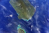 Apolima Strait with Savai'i (top) and the tip of Upolu below.
 -
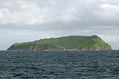 Apolima island.
 -
 Heading by boat towards uninhabited Nu'ulopa island (left) with Apolima island (right)
 -
 Map of Samoa showing Apolima Strait between Upolu (right) and Savai'i (left).


See also
- Samoan Islands
- Geography of Samoa
References
13°49′08″S 172°10′19″W / 13.819°S 172.172°W / -13.819; -172.172
- v
- t
- e


