A847 road
Road in Scotland

 | |
|---|---|
| Route information | |
| Length | 14.7 mi[1] (23.7 km) |
| 55°46′55″N 6°14′56″W / 55.7819°N 6.249°W / 55.7819; -6.249 | |
| Major intersections | A846 |
| South end | Portnahaven 55°40′51″N 6°30′23″W / 55.6808°N 6.5063°W / 55.6808; -6.5063 |
| Location | |
| Country | United Kingdom |
| Constituent country | Scotland |
| Road network | |
The A847 road is one of the two principal roads of Islay in the Inner Hebrides off the west coast of mainland Scotland.
It connects Bridgend, at a junction with the A846 road, with Portnahaven at the southern end of the Rinns of Islay peninsula. It is some 14+1⁄2 miles (23 km) long.
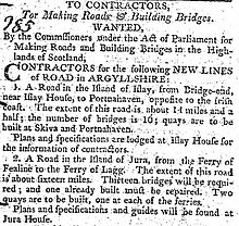
The road was completed in 1806 following the route surveyed by John Langlands of Campbeltown.[2]
Settlements on or near the A847
North to South
- Bridgend
- Blackrock
- Bruichladdich
- Port Charlotte
- Nerabus (Nereabolls)
- Easter Ellister
- Portnahaven
References

55°44′48″N 6°22′25″W / 55.74677°N 6.37357°W / 55.74677; -6.37357
 | This Scotland road or road transport-related article is a stub. You can help Wikipedia by expanding it. |
- v
- t
- e


