Élise-Daucourt
Commune in Grand Est, France
Location of Élise-Daucourt

(2020–2026) Guillaume Achard-Corompt[1]
1
(2021)[2]
51228 /51800
Élise-Daucourt (French pronunciation: [eliz dokuʁ]) is a commune in the Marne department in north-eastern France. The commune consists of 2 villages, Élise and Daucourt, which are 1 mile apart. Both villages were separate communes until 1965, when they merged. Since the merger Élise is often called Élise-Daucourt. Both villages lie about 6 km south of Sainte-Menehould, the nearest regional town.
See also
-
 Church of St. Julian in Élise
 -
 Former town hall of Élise
 -
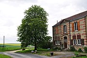
 Rural corner in Élise


References
- ^ "Répertoire national des élus: les maires" (in French). data.gouv.fr, Plateforme ouverte des données publiques françaises. 13 September 2022.
- ^ "Populations légales 2021" (in French). The National Institute of Statistics and Economic Studies. 28 December 2023.
External links
Wikimedia Commons has media related to Élise-Daucourt.
- v
- t
- e
 Communes of the Marne department
- Ablancourt
- Aigny
- Allemanche-Launay-et-Soyer
- Allemant
- Alliancelles
- Ambonnay
- Ambrières
- Anglure
- Angluzelles-et-Courcelles
- Anthenay
- Aougny
- Arcis-le-Ponsart
- Argers
- Arrigny
- Arzillières-Neuville
- Athis
- Aubérive
- Aubilly
- Aulnay-l'Aître
- Aulnay-sur-Marne
- Auménancourt
- Auve
- Avenay-Val-d'Or
- Avize
- Aÿ-Champagne
- Baconnes
- Bagneux
- Le Baizil
- Bannay
- Bannes
- Barbonne-Fayel
- Baslieux-lès-Fismes
- Baslieux-sous-Châtillon
- Bassu
- Bassuet
- Baudement
- Baye
- Bazancourt
- Beaumont-sur-Vesle
- Beaunay
- Beine-Nauroy
- Belval-en-Argonne
- Belval-sous-Châtillon
- Bergères-lès-Vertus
- Bergères-sous-Montmirail
- Berméricourt
- Berru
- Berzieux
- Bétheniville
- Bétheny
- Bethon
- Bettancourt-la-Longue
- Bezannes
- Bignicourt-sur-Marne
- Bignicourt-sur-Saulx
- Billy-le-Grand
- Binarville
- Blacy
- Blaise-sous-Arzillières
- Blancs-Coteaux
- Blesme
- Bligny
- Boissy-le-Repos
- Bouchy-Saint-Genest
- Bouilly
- Bouleuse
- Boult-sur-Suippe
- Bourgogne-Fresne
- Boursault
- Bouvancourt
- Bouy
- Bouzy
- Brandonvillers
- Branscourt
- Braux-Sainte-Cohière
- Braux-Saint-Remy
- Bréban
- Le Breuil
- Breuil-sur-Vesle
- Breuvery-sur-Coole
- Brimont
- Brouillet
- Broussy-le-Grand
- Broussy-le-Petit
- Broyes
- Brugny-Vaudancourt
- Brusson
- Le Buisson
- Bussy-le-Château
- Bussy-le-Repos
- Bussy-Lettrée
- Caurel
- La Caure
- Cauroy-lès-Hermonville
- La Celle-sous-Chantemerle
- Cernay-en-Dormois
- Cernay-lès-Reims
- Cernon
- Chaintrix-Bierges
- Châlons-en-Champagnepref
- Châlons-sur-Vesle
- Chaltrait
- Chambrecy
- Chamery
- Champaubert
- Champfleury
- Champguyon
- Champigneul-Champagne
- Champigny
- Champillon
- Champlat-et-Boujacourt
- Champvoisy
- Changy
- Chantemerle
- Chapelaine
- La Chapelle-Felcourt
- La Chapelle-Lasson
- La Chapelle-sous-Orbais
- Charleville
- Charmont
- Les Charmontois
- Le Châtelier
- Châtelraould-Saint-Louvent
- Châtillon-sur-Broué
- Châtillon-sur-Marne
- Châtillon-sur-Morin
- Châtrices
- Chaudefontaine
- Chaumuzy
- La Chaussée-sur-Marne
- Chavot-Courcourt
- Le Chemin
- Cheminon
- Chenay
- Cheniers
- La Cheppe
- Cheppes-la-Prairie
- Chepy
- Cherville
- Chichey
- Chigny-les-Roses
- Chouilly
- Clamanges
- Clesles
- Cloyes-sur-Marne
- Cœur-de-la-Vallée
- Coizard-Joches
- Compertrix
- Condé-sur-Marne
- Conflans-sur-Seine
- Congy
- Connantray-Vaurefroy
- Connantre
- Contault
- Coole
- Coolus
- Corbeil
- Corfélix
- Cormicy
- Cormontreuil
- Cormoyeux
- Corribert
- Corrobert
- Corroy
- Coulommes-la-Montagne
- Coupetz
- Coupéville
- Courcelles-Sapicourt
- Courcemain
- Courcy
- Courdemanges
- Courgivaux
- Courjeonnet
- Courlandon
- Courmas
- Courtagnon
- Courtémont
- Courthiézy
- Courtisols
- Courville
- Couvrot
- Cramant
- La Croix-en-Champagne
- Crugny
- Cuchery
- Cuis
- Cuisles
- Cumières
- Cuperly
- Damery
- Dampierre-au-Temple
- Dampierre-le-Château
- Dampierre-sur-Moivre
- Dizy
- Dommartin-Dampierre
- Dommartin-Lettrée
- Dommartin-sous-Hans
- Dommartin-Varimont
- Dompremy
- Dontrien
- Dormans
- Drosnay
- Drouilly
- Éclaires
- Écollemont
- Écriennes
- Écueil
- Écury-le-Repos
- Écury-sur-Coole
- Élise-Daucourt
- Épense
- Épernaysubpr
- Époye
- Escardes
- Esclavolles-Lurey
- Les Essarts-lès-Sézanne
- Les Essarts-le-Vicomte
- Esternay
- Étoges
- Étréchy
- Étrepy
- Euvy
- Fagnières
- Faux-Fresnay
- Faux-Vésigneul
- Faverolles-et-Coëmy
- Favresse
- Fèrebrianges
- Fère-Champenoise
- Festigny
- Fismes
- Flavigny
- Fleury-la-Rivière
- Florent-en-Argonne
- Fontaine-Denis-Nuisy
- Fontaine-en-Dormois
- Fontaine-sur-Ay
- La Forestière
- Francheville
- Le Fresne
- Frignicourt
- Fromentières
- Le Gault-Soigny
- Gaye
- Germaine
- Germigny
- Germinon
- Giffaumont-Champaubert
- Gigny-Bussy
- Givry-en-Argonne
- Givry-lès-Loisy
- Gizaucourt
- Glannes
- Gourgançon
- Les Grandes-Loges
- Granges-sur-Aube
- Gratreuil
- Grauves
- Gueux
- Hans
- Haussignémont
- Haussimont
- Hauteville
- Hautvillers
- Heiltz-le-Hutier
- Heiltz-l'Évêque
- Heiltz-le-Maurupt
- Hermonville
- Herpont
- Heutrégiville
- Hourges
- Huiron
- Humbauville
- Igny-Comblizy
- Isles-sur-Suippe
- Isle-sur-Marne
- Isse
- Les Istres-et-Bury
- Jâlons
- Janvilliers
- Janvry
- Joiselle
- Jonchery-sur-Suippe
- Jonchery-sur-Vesle
- Jonquery
- Jouy-lès-Reims
- Jussecourt-Minecourt
- Juvigny
- Lachy
- Lagery
- Landricourt
- Larzicourt
- Laval-sur-Tourbe
- Lavannes
- Lenharrée
- Leuvrigny
- Lhéry
- Lignon
- Linthelles
- Linthes
- Lisse-en-Champagne
- Livry-Louvercy
- Loisy-en-Brie
- Loisy-sur-Marne
- Loivre
- Ludes
- Luxémont-et-Villotte
- Maffrécourt
- Magenta
- Magneux
- Mailly-Champagne
- Mairy-sur-Marne
- Maisons-en-Champagne
- Malmy
- Mancy
- Marcilly-sur-Seine
- Mardeuil
- Mareuil-en-Brie
- Mareuil-le-Port
- Marfaux
- Margerie-Hancourt
- Margny
- Marigny
- Marolles
- Marsangis
- Marson
- Massiges
- Matignicourt-Goncourt
- Matougues
- Maurupt-le-Montois
- Mécringes
- Le Meix-Saint-Epoing
- Le Meix-Tiercelin
- Merfy
- Merlaut
- Méry-Prémecy
- Les Mesneux
- Le Mesnil-sur-Oger
- Minaucourt-le-Mesnil-lès-Hurlus
- Mœurs-Verdey
- Moiremont
- Moivre
- Moncetz-l'Abbaye
- Moncetz-Longevas
- Mondement-Montgivroux
- Montbré
- Montépreux
- Montgenost
- Monthelon
- Montigny-sur-Vesle
- Montmirail
- Montmort-Lucy
- Mont-sur-Courville
- Morangis
- Morsains
- Moslins
- Mourmelon-le-Grand
- Mourmelon-le-Petit
- Moussy
- Muizon
- Mutigny
- Nanteuil-la-Forêt
- Nesle-la-Reposte
- Nesle-le-Repons
- La Neuville-au-Pont
- La Neuville-aux-Bois
- La Neuville-aux-Larris
- Neuvy
- Nogent-l'Abbesse
- Noirlieu
- Norrois
- La Noue
- Nuisement-sur-Coole
- Œuilly
- Ognes
- Oiry
- Olizy
- Omey
- Orbais-l'Abbaye
- Orconte
- Ormes
- Outines
- Outrepont
- Oyes
- Pargny-lès-Reims
- Pargny-sur-Saulx
- Passavant-en-Argonne
- Passy-Grigny
- Péas
- Les Petites-Loges
- Pévy
- Pierre-Morains
- Pierry
- Pleurs
- Plichancourt
- Plivot
- Pocancy
- Pogny
- Poilly
- Poix
- Pomacle
- Pontfaverger-Moronvilliers
- Ponthion
- Possesse
- Potangis
- Pouillon
- Pourcy
- Pringy
- Prosnes
- Prouilly
- Prunay
- Puisieulx
- Queudes
- Rapsécourt
- Recy
- Reimssubpr
- Reims-la-Brûlée
- Remicourt
- Reuves
- Réveillon
- Rieux
- Rilly-la-Montagne
- Les Rivières-Henruel
- Romain
- Romery
- Romigny
- Rosnay
- Rouffy
- Rouvroy-Ripont
- Sacy
- Saint-Amand-sur-Fion
- Saint-Bon
- Saint-Brice-Courcelles
- Saint-Chéron
- Sainte-Gemme
- Sainte-Marie-à-Py
- Sainte-Marie-du-Lac-Nuisement
- Sainte-Menehould
- Saint-Étienne-au-Temple
- Saint-Étienne-sur-Suippe
- Saint-Eulien
- Saint-Euphraise-et-Clairizet
- Saint-Germain-la-Ville
- Saint-Gibrien
- Saint-Gilles
- Saint-Hilaire-au-Temple
- Saint-Hilaire-le-Grand
- Saint-Hilaire-le-Petit
- Saint-Imoges
- Saint-Jean-devant-Possesse
- Saint-Jean-sur-Moivre
- Saint-Jean-sur-Tourbe
- Saint-Just-Sauvage
- Saint-Léonard
- Saint-Loup
- Saint-Lumier-en-Champagne
- Saint-Lumier-la-Populeuse
- Saint-Mard-lès-Rouffy
- Saint-Mard-sur-Auve
- Saint-Mard-sur-le-Mont
- Saint-Martin-aux-Champs
- Saint-Martin-d'Ablois
- Saint-Martin-l'Heureux
- Saint-Martin-sur-le-Pré
- Saint-Masmes
- Saint-Memmie
- Saint-Ouen-Domprot
- Saint-Pierre
- Saint-Quentin-le-Verger
- Saint-Quentin-les-Marais
- Saint-Quentin-sur-Coole
- Saint-Remy-en-Bouzemont-Saint-Genest-et-Isson
- Saint-Remy-sous-Broyes
- Saint-Remy-sur-Bussy
- Saint-Saturnin
- Saint-Souplet-sur-Py
- Saint-Thierry
- Saint-Thomas-en-Argonne
- Saint-Utin
- Saint-Vrain
- Sapignicourt
- Sarcy
- Saron-sur-Aube
- Sarry
- Saudoy
- Savigny-sur-Ardres
- Scrupt
- Selles
- Sept-Saulx
- Sermaize-les-Bains
- Sermiers
- Servon-Melzicourt
- Serzy-et-Prin
- Sézanne
- Sillery
- Sivry-Ante
- Sogny-aux-Moulins
- Sogny-en-l'Angle
- Soizy-aux-Bois
- Somme-Bionne
- Sommepy-Tahure
- Sommesous
- Somme-Suippe
- Somme-Tourbe
- Somme-Vesle
- Somme-Yèvre
- Sompuis
- Somsois
- Songy
- Souain-Perthes-lès-Hurlus
- Soudé
- Soudron
- Soulanges
- Soulières
- Suippes
- Suizy-le-Franc
- Taissy
- Talus-Saint-Prix
- Thaas
- Thibie
- Thiéblemont-Farémont
- Thil
- Thillois
- Le Thoult-Trosnay
- Tilloy-et-Bellay
- Tinqueux
- Togny-aux-Bœufs
- Tours-sur-Marne
- Tramery
- Trécon
- Tréfols
- Trépail
- Treslon
- Trigny
- Trois-Fontaines-l'Abbaye
- Trois-Puits
- Troissy
- Unchair
- Vadenay
- Val de Livre
- Val-des-Marais
- Val-de-Vesle
- Val-de-Vière
- Valmy
- Vanault-le-Châtel
- Vanault-les-Dames
- Vandeuil
- Vandières
- Vassimont-et-Chapelaine
- Vatry
- Vauchamps
- Vauciennes
- Vauclerc
- Vaudemange
- Vaudesincourt
- Vavray-le-Grand
- Vavray-le-Petit
- Vélye
- Ventelay
- Venteuil
- Verdon
- Vernancourt
- Verneuil
- Verrières
- Vert-Toulon
- Verzenay
- Verzy
- Vésigneul-sur-Marne
- La Veuve
- Le Vézier
- Le Vieil-Dampierre
- Vienne-la-Ville
- Vienne-le-Château
- Ville-Dommange
- Ville-en-Selve
- Ville-en-Tardenois
- Villeneuve-la-Lionne
- La Villeneuve-lès-Charleville
- Villeneuve-Renneville-Chevigny
- Villeneuve-Saint-Vistre-et-Villevotte
- Villers-Allerand
- Villers-aux-Bois
- Villers-aux-Nœuds
- Villers-en-Argonne
- Villers-Franqueux
- Villers-le-Château
- Villers-le-Sec
- Villers-Marmery
- Villeseneux
- La Ville-sous-Orbais
- Ville-sur-Tourbe
- Villevenard
- Villiers-aux-Corneilles
- Vinay
- Vincelles
- Vindey
- Virginy
- Vitry-en-Perthois
- Vitry-la-Ville
- Vitry-le-Françoissubpr
- Voilemont
- Vouarces
- Vouillers
- Vouzy
- Vraux
- Vrigny
- Vroil
- Wargemoulin-Hurlus
- Warmeriville
- Witry-lès-Reims
- pref: prefecture
- subpr: subprefecture
| Authority control databases: National |
|
|---|
 | This Marne geographical article is a stub. You can help Wikipedia by expanding it. |
- v
- t
- e


